
| Method | Copper engraved with original hand colour |
| Artist | d'Anville, Jean Baptiste Bourguignon |
| Published | London. Publish'd by Laurie & Whittle, No. 53, Fleet Street, as the Act directs, 12th May 1794 |
| Dimensions | 1040 x 1200 mm |
| Notes |
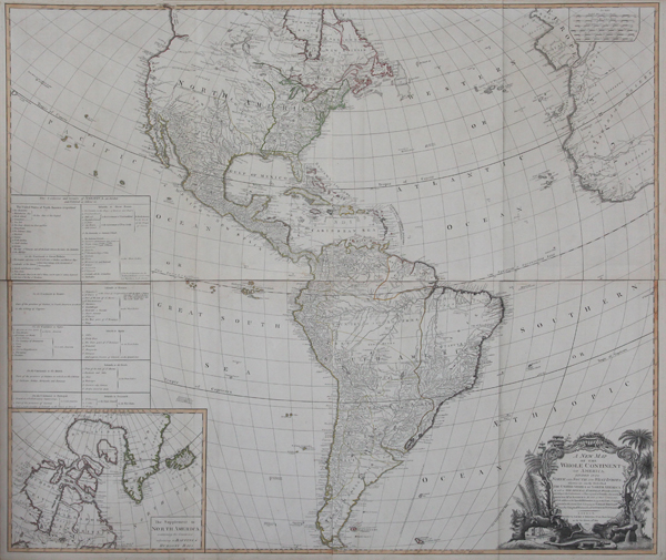
An impressive and very large wall map of the Americas, North and South, following d'Anville and printed over four sheets by Laurie & Whittle for Kitchin's General Atlas, describing the Whole Universe: being a complete collection of the most approved maps extant; corrected with the greatest care, and augmented from the last edition of D'Anville and Robert with many improvements by other eminent geographers. The map shows the extent of the New World, updated to reflect the divisions settled at the Treaty of Versailles. Along the eastern coast of North America, the United States, newly formed after the conclusion of the Revolutionary War in 1783, are outlined in green. The remainder of North America is divided up into the Spanish territories of New Mexico, New Navarra, New Biscay, California, and the former French territory of Louisiana. To the north, eastern Canada is labelled as New Britain, Labrador, and the Province of Quebec. The north western regions of the continent are almost completely blank, apart from 'New Albion' north of California, which carries a note about the anchorage of Sir Francis Drake, and the cryptic Fou Sang, a purported colony of the Chinese on the coast north of George's Sound. By contrast, the West Indies, and Central and South America are very well mapped. Off the coast of South America, the Galapagos are given the whimsical title of the 'Inchanted Isles.' On the other side of the Atlantic, parts of Europe and Africa are shown, though the Pacific is mostly devoid of detail. The blank spaces of the map are instead occupied by a boxed inset map of Hudson Bay and Baffin Bay, with Greenland and Iceland also featured. Above this, a large table allots various territories to the European powers, and also lists the constituent colonies that now make up the United States. The map is outlined in original hand colour, and is further embellished in the bottom right corner by a large decorative cartouche, featuring various botanical and faunal emblems of the Americas, including a beaver and a crocodile, as well as a feathered head-dress and a quiver of arrows. Full title reads: A New Map of the Whole Continent of America, Divided into North and South and West Indies, wherein are exactly Described the United States of North America as well as the Several European Possessions according to the Preliminaries of Peace signed at Versailles Jan 20.1783. Compiled from Mr. d'Anville's Maps of that Continent, with the addition of the Spanish Discoveries in 1775 to the North of California & Corrected in the several Parts belonging to Great Britain, from the Original Materials of Governor Pownall, MP. Jean Baptiste Bourguignon d'Anville (11th July 1697 - 28th January 1782) was a French cartographer, geographer, and antiquarian, whose rigourous standards of geographic reference revolutionised map making during the latter half of the eighteenth century. Rather than rely on the authority of earlier cartographers in the creation of his maps, d'Anville insisted on verifiable evidence. The resulting maps looked vastly different from the work of his predecessors. Ornamentation was stripped back, and dubious locations were simply left blank. In 1754 he became a member of the Académie des Inscriptions et Belles Lettres, and in 1775 was appointed first geographer to King Louis XVI. Robert Laurie (c.1755-1836) was a British engraver, mezzotint artist, and publisher. In 1776, he was awarded a prize by the Society of Arts for the invention of a method of producing colour-printed mezzotints. Laurie succeeded the publisher Robert Sayer after the latter's death in 1794, and, in partnership with James Whittle, continued Sayer's prolific and well-established business on the Fleet Street, issuing prints, maps, illustrated books, charts, and nautical works. Following Laurie's retirement in 1812, Whittle continued in business with his former partner's son, Richard Holmes Laurie, who gained sole ownership of the business in 1818 with the death of Whittle. Condition: Printed over four sheets, folded and joined as issued. Original outline colour. Minor tears to folds. Minor time toning to edges of sheet, not affecting map. |
| Framing | unmounted |
| Price | £2,000.00 |
| Stock ID | 43627 |