
| Method | Copper engraved with hand colour |
| Artist | Wells, Edward |
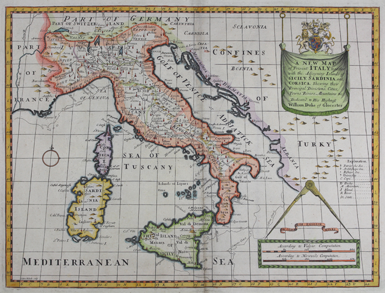
| Published | Dedicated to His Highness William Duke of Glocester. Sutton Nicholls sculp. [Oxford, 1701] |
| Dimensions | 370 x 490 mm |
| Notes |
An early eighteenth century map of 'present' Italy, as opposed to its companion of 'antient' Italy, from Wells' A Treatise of Antient and Present Geography, together with a Sett of Maps in Folio. The map depicts the Italy of Wells' time, as well as parts of the neighbouring nations and regions of France, Switzerland, Germany, the Ottoman territories on the Adriatic, Sicily, Sardinia, and Corsica. Borders and sea coasts are outlined in hand colour, and important cities and towns are picked out in red. Mountain ranges and rivers are shown pictorially, as is the fiery cone of Mt Etna on Sicily. A lightly traced shadow off some of the coasts provides an alternative positioning of the peninsula, according to Sanson. Along the right hand side of the map are a number of cartouches and keys, providing the dedication to William Duke of Gloucester, and a scale in English miles. Edward Wells' A Treatise of Antient and Present Geography, together with a Sett of Maps in Folio was developed for and dedicated to William, Duke of Gloucester, who was at the time a pupil at Oxford. Wells was a teacher of mathematics and geography at Christ Church, where the young heir to the throne had begun his studies in 1700 at age 11. Wells designed his maps for instructional use in the geography courses he taught and his clear and direct cartographic presentation proved popular with the general public as well. Sadly, the young Duke of Gloucester died shortly after their completion, but the maps became something of a surprise commercial success, and the atlas received several reprintings well into the 1730s. These decorative maps provide a fascinating snapshot of British understanding of the world at the outset of the 18th century, and were prized for their geographical accuracy and the strength of their engraved images. Edward Wells (1667-1727) was a British mathematician, theologian, and geographer, best known for his fractious and bombastic attacks on dissenters, Presbyterians, and his fellow churchman and former pupil, Browne Willis. In addition to his duties as a clergyman, Wells also taught geology, mathematics, and theology at Christ Church, Oxford. In addition to producing a Greek critical edition of the New Testament, he published a collection of maps of the ancient world, dedicated to one of his students, the young Duke of Gloucester. Sutton Nicholls (1668-1729) was a British engraver, print seller, draughtsman and globe maker. Although best known for his panoramic views of the cities of London and Westminster, Sutton also produced prospects of gentlemen's seats. A majority of his work was commissioned by publishers. Condition: Central vertical fold, as issued. Time toning and creasing to central fold. Blank on verso. |
| Framing | unmounted |
| Price | £375.00 |
| Stock ID | 50220 |