
| Method | Copper engraved with early hand colour |
| Artist | Bowen, Emanuel |
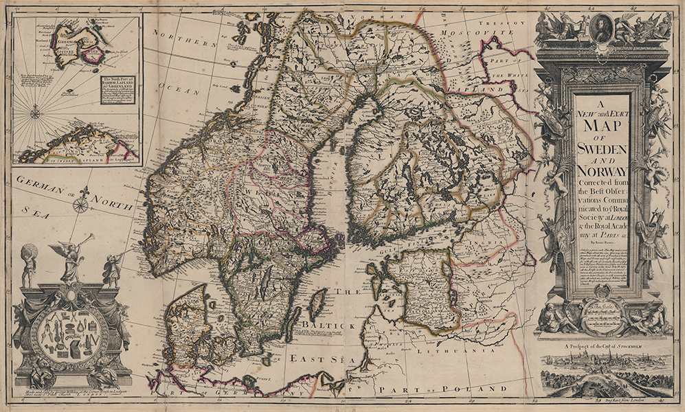
| Published | By Eman. Bowen. Made and Sold by George Willdey at the Corner House in Ludgate Street next St Pauls Church, London. [c.1717] |
| Dimensions | 580 x 980 mm |
| Notes |
A rare and detailed early eighteenth century large scale map of Scandinavia, encompassing modern day Denmark, Norway, Sweden, Finland, Estonia, Latvia, Lithuania, and parts of Russia, Poland, and Germany. National and regional borders are outlined in early hand colour, mountains, rivers, lakes, and forests are shown pictorially, and the map is replete with notes of local interest. Disputed territory between Russia and Finland is labelled as a desert of 'Lakes and Morasses' near another note that reads 'Here Rubies are found.' Across the Kalmar straits, the island of Oland is described as rich with game, and a popular destination for royal hunts, while a famous maelstrom is depicted as a spiralling swirl off the north-western coast of Norway. In the top left corner of the map, a large inset boxed map shows Spitsbergen (Svalbard), here also labelled 'Greenland,' noted for the rich whaling that tempts ships from Holland and Hamburg every year. Along the right side of the map, a very large cartouche enclosing the title is bordered by weapons of war, armorial trophies, bound captives, and symbols of military victory, above a vignette of the city of Stockholm. Below the title is a lengthy advertisement for George Willdey's various products, including the grand challenge that no artist in the Universe can exceed him either in the choice of goods available at his shop, or the reasonable rates he charges for his stock. In the bottom left, another decorative cartouche, flanked with allegorical figures, appears to announce more of Willdey's products, including combs, scissors, razors, snuff-boxes, guns, trinket boxes, pocket-watches, and other curios. The map, available alongside others of a similar size and composition, was allegedly available from Willdey for 9 pence each, and was thus likely to have been separately published, as much, it appears, as an advertisement for Willdey's shop as anything else. The current example, featuring three vertical folds, was undoubtedly bound into a composite atlas, another of Willdey's numerous ventures. Bowen, Emanuel (c.1693-1767) was one of the leading eighteenth century map and print sellers and engravers in London. Appointed Engraver of maps to George II of England and possibly Louis XV of France. His apprentices included Thomas Kitchin and Thomas Jeffreys. He collaborated with other map makers of his time, including the Bowles family and John Owen. George Willdey (d.1737) was a mapseller active in the early eighteenth century. He is also known to have sold prints, optical instruments, spectacles, toys, and ceramics. Between c.1707 and 1711 he worked in partnership with Timothy Brandreth, and between 1711 and 1713 with Charles Price. In around 1730 he acquired the plates to Saxton's atlas. Condition: Vertical folds, as issued. Time toning, creasing, and some splitting to folds. Time toning and repaired tears to margins. Old adhesive tape on verso, otherwise blank. |
| Framing | unmounted |
| Price | £3,000.00 |
| Stock ID | 53434 |