
| Method | Copper engraved with hand colour |
| Artist | Neele, Samuel John after Pawley, George |
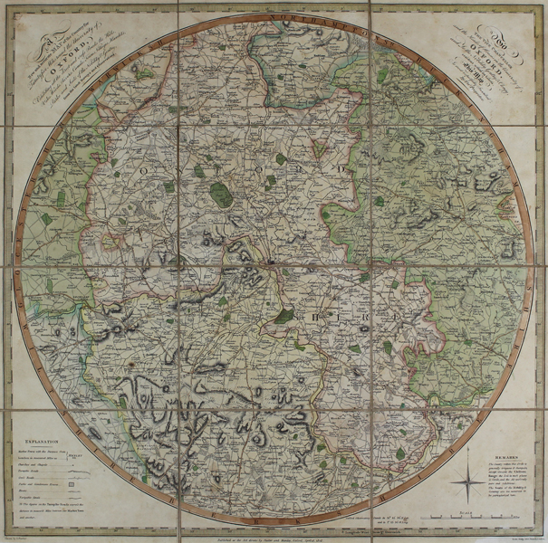
| Published | Published as the Act directs by Slatter and Munday, Oxford, April 15, 1805 |
| Dimensions | 453 x 447 mm |
| Notes |
A scarce, circular printed, folding map of Oxfordshire, centred on the City of Oxford. Full title reads: A New and Accurate Map of the Country for Twenty five Miles round the university of Oxford, Exhibiting all the direct and cross Roads, the Hills, Vales, Woods, Rivers, Canals, Towns, Villages, Hamlets, Parks and Seats of the Nobility & Gentry, from the latest surveys and observations. The map is addressed: To The Vice Chancellor and the Heads of Houses in the University of Oxford, and to the Nobility, Gentry and Clergy, resident within its limits, This Map Is most respectfully Inscribed by the Proprietor. Samuel John Neele (1758 1824) headed a family of engravers and publishers mainly working from 352 Strand, London. He worked on numerous publications throughout his lifetime trading with his younger brother George as "S. & G. Neele" from 1813 to 1814, and with his son, James as "Neele and Son" from 1816 to 1824. George Pawley (fl.1805-1822) was a geographer and mapmaker based in London. He produced this map engraved by Samuel John Neele, as well as Pawley's General Atlas (1819) and Pawley's Minor Atlas (1822) both engraved by Samuel and George Neele. Condition: Sheet dissected into 12 sheets and laid on linen, as issued. Slight overall time toning and minor dirt build-up. |
| Framing | mounted |
| Price | £975.00 |
| Stock ID | 43947 |