
| Method | Copper engraved with hand colour |
| Artist | Bowen, Thomas |
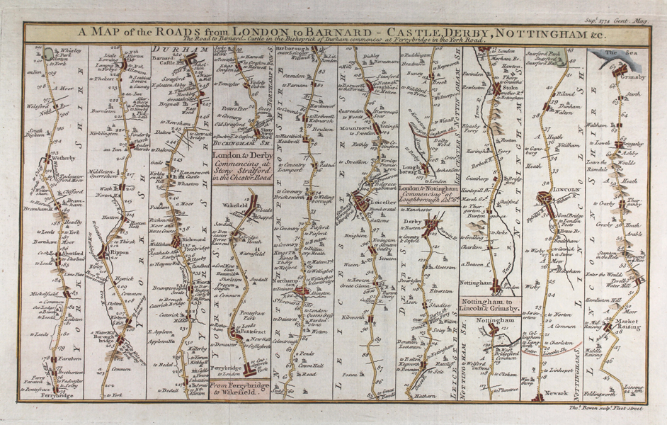
| Published | Supt. 1774 Gent. Mag. Thos. Bowen sculpt. Fleet Street |
| Dimensions | 172 x 285 mm |
| Notes |
A folding sheet of five strip maps of the roads of Yorkshire, Durham, Northamptonshire, Leicestershire, Derbyshire, Nottinghamshire, and Lincolnshire, engraved by Thomas Bowen for Sylvanus Urban's 1774 Gentleman's Magazine and Historical Chronicle. The first strip covers Ferrybridge to Barnard Castle, passing Wetherby, Ripon, and Richmond. The second covers Ferrybridge to Wakefield via Pontefract. The third is the road from London to Derby, commencing at Stony Stratford and passing through Northampton, Harborough, Leicester, and Stanford. The fourth, London to Nottingham, commences at Loughborough. The fifth and final strip, Nottingham to Grimsby, passes Stoke, Newark, Lincoln, and Market Rasen. Thomas Bowen (1733-1790) was an English engraver, map-maker, and printseller. He worked with his father, Emmanuel Bowen, on the Royal English Atlas and the Atlas Angelicanus, which he completed after his fathers death in 1767. He engraved maps for Taylor & Skinner's Survey of the Roads of North Britain and many other publications. Condition: Vertical folds as issued. Minor time toning to edges of sheet. Blank on verso. |
| Framing | unmounted |
| Price | £45.00 |
| Stock ID | 50212 |