
| Method | Copper engraved with early hand colour |
| Artist | Cary, John after Davis, Richard |
| Published | By Richard Davis of Lewknor, Topographer to His Majesty. London, Published by J. Cary for R. Davis of Lewknor, as the Act directs Augst. 1. 1797 |
| Dimensions | 650 x 475 mm |
| Notes |
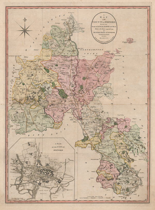
The keyplate to Davis' rare and historically significant 16-sheet survey of the county of Oxfordshire, presented in full early wash colour and with an inset plan of the City of Oxford to bottom left. The map, engraved by Cary, is a reduced scale version of the full 2 inch to the mile survey, with dividing lines and Roman numerals in the bottom right of each box providing a key to the 16 sheets of the full survey. To date, only 159 copies are known. The Davis survey occupies a very important place in the mapping of Oxfordshire, being the first map of the County on a scale of 2 inches to the mile, and succeeding Jefferys' fine 32 panel folding map of Oxfordshire from 1767.The plates were engraved by Cary from draughts by Richard Davis, a land surveyor from Lewknor in Oxfordshire. Davis's name had first appeared some years earlier in 1792 when he advertised in Jackson's Oxford Journal offering services to survey or plan estates or assist in the selling or letting of houses. In the following years he was especially active in Oxfordshire and the city of Oxford where the University proved a rewarding source of commissions. In 1790 Davis advertised his intention to publish in 1792 a survey of Oxfordshire on a scale of 2 inches to 1 mile, this scale being specifically chosen to complement the 18-sheet map of Berkshire by John Rocque who had held the post of Topographer to His Majesty, a post to which Davis himself was appointed in 1786. Subscriptions came slowly however, and it was not until 1797 that the Oxfordshire survey was finally published on 16 sheets at £3 10s 6d, including full wash colour and a key map. All subscribers' copies were numbered on the title sheet and individually signed by Davis himself. The highest recorded serial number of 159 suggesting a total printing of less than 200 copies. Of particular interest is the plan of the University and City of Oxford, similar in scale and ichnographical detail to the plan of the city by Isaac Taylor in 1751 but with some updating, notably the intersection of the Oxford Canal, which opened in 1790. The cartographical detail is immense, well worthy of an estate surveyor of Davis's reputation, and takes full advantage of the larger scale. In the villages and rural areas almost every house and farm is shown with its land, and even in the towns there is great effort made to make them ichnographically correct. The road system is extensive, from major roads with their distances from Oxford and London, and between the major towns, down to minor roads and bridle paths. Further detail includes hills and woods, heaths, parks and commons, and mills, churches and farms, whilst gentlemen's seats and large houses are shown in profusion. The boundaries of the city of Oxford extend from Folly Bridge to St. Giles and from Botley to St. Clements, with the emptiness of Cowley Common separating the village of Cowley from the City. John Cary was fast establishing a reputation as one of the foremost map-makers of his day, skilled in engraving, globe-making and publishing. He was described by the carto-bibliographer Sir George Frodham, as the most representative, able and prolific English cartographer. Davis continued as a land surveyor until his death in 1814, but the present survey, for which he received 50 guineas from the Society of Arts, was his only contribution to English county cartography. John Cary (1755-1835) was an English cartographer, engraver, globe maker and publisher, often working with his brothers George and Francis. In 1770, he was apprenticed to William Palmer, and became surveyor of roads to the general post office around 1794. He is best known for his English county atlases, particularly Cary's New and Correct English Atlas, published in 1787-1789, and the miniature Traveller's Companion. He also engraved the plates for Robert Gough's edition of Camden's Britannia, which was published in 1806. Condition: Central horizontal fold, as issued. Minor foxing to sheet. Minor tears and creases to margins. Old tear repairs and verdigris from old colour to verso, otherwise blank. |
| Framing | unmounted |
| Price | £750.00 |
| Stock ID | 52234 |