
| Method | Copper engraved with hand colour |
| Artist | Kitchin, Thomas |
| Published | London, Printed for T. Kitchin at the Star, Holborn Hill; Robt. Sayer at the Buck in Fleet Street; Carington Bowles in St Paul's Church Yard; and H. Parker opposite Birchin Lane in Cornhill [1773] |
| Dimensions | 480 x 535 mm |
| Notes |
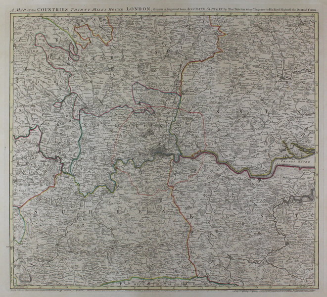
A large and impressive eighteenth century map of the area within thirty miles of the City of London, encompassing Middlesex and adjoining parts of Buckinghamshire, Bedfordshire, Hertfordshire, Essex, Kent, Surrey, Hampshire, and Berkshire. County boundaries are picked out in outline colour, and the outer limit of the London Penny Post, re-established by an Act of Parliament in 1765, is marked in red. The map is very detailed, with a graphic key along the bottom margin showing the icons for towns and villages, close roads, open roads, churches, the seats and stately homes of nobility and gentlemen, parks, wind mills, and water mills. Judging by the impressive publication line at the bottom right corner of the plate, the map was separately printed and used for a number of different purposes, being sold by Kitchin, Sayer, Carington Bowles, and Parker simultaneously. The central fold on this example suggests that it was at some stage bound into an atlas or extra illustrated book, though what this might have been is unknown. Thomas Kitchin (1718-1784) was one of the best and most prolific engravers of the eighteenth century. He issued The General Atlas, Describing the Whole Universe , first published in 1773, and regularly reissued thereafter. His work also included a large number of maps of the English counties, particularly for the London Magazine (1747-1760), the Universal Magazine (1747-1766), and for Dodsley's England Illustrated (1764). Other maps were published in conjunction with Emanuel Bowen in the Large English Atlas and the Royal English Atlas (1763). Robert Sayer (1725-1794) was one of the most prolific and successful British publishers, cartographers, and print-sellers of the Georgian era. Following his brother's marriage to the daughter in law of the publisher John Overton, Sayer continued the business, branching out into sea charts, maritime atlases, and general maps. In addition to his cartographic achievements, Sayer was also instrumental in growing the public taste for prints after paintings, particularly those by Johan Zoffany, with whom he developed a lifelong friendship as well as a lucrative business partnership. Following his death, the business was continued by Laurie and Whittle. Carington Bowles (1724-1793) was one of the leading print publishers, printers and sellers of the eighteenth century. He apprenticed with his father John Bowles and worked with him as John Bowles & Son from 1753 to 1762, after which he took over his uncle's business in St Paul's Churchyard, London. Condition: Pressed central vertical fold. Printers crease to bottom left corner of sheet. Blank on verso. |
| Framing | unmounted |
| Price | £450.00 |
| Stock ID | 46909 |