
| Method | Copper engraved with hand colour |
| Artist | Lea, Philip |
| Published | Sold by Philip Lea at the Atlas & Hercules in Cheapside. London. [c. 1690] |
| Dimensions | 366 x 482 mm |
| Notes |
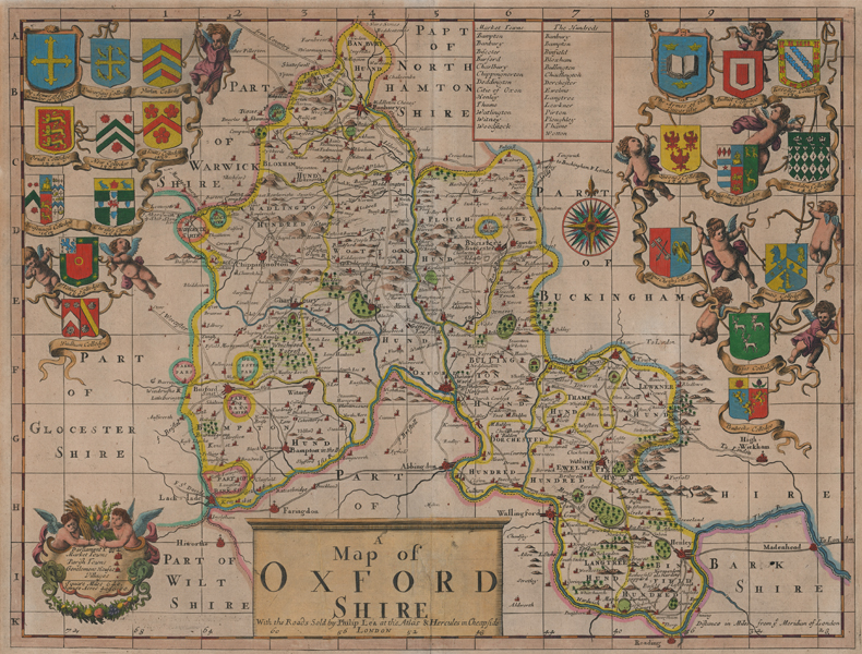
A very scarce decorative map of the county of Oxfordshire, divided into Hundreds and with the roads marked. A boxed list provides the names of principle market towns and the Hundreds. Below is a large radiate compass with fleur-de-lis pointer. The title is boxed and topped with a simple four barred entablature, and a key in the bottom left corner is framed by a pair of cherubs carrying symbols of agricultural abundance. A pair of elaborate ribbons supported by more cherubs to the top left and right of the map show the arms of the colleges, as well as those of the University and King Alfred, the apocryphal founder of the University. This edition shows evidence of removal of another publication line left of the centre title, likely that of John Sellers (1632-1697) at the West Side of the Royal Exchange. During the 1680s, Sellers worked on a number of county maps for an Atlas Anglicanus, though after his publication of Lea's revised Saxton in 1689, Sellers abandoned the Atlas Anglicanus and sold the plates to Lea, who reworked and reissued them some years later. Philip Lea (fl.1683-1700) was a British map maker, globe maker, engraver, and publisher, as well as a manufacturer of scientific and cartographic instruments. The majority of his maps were reworkings of plates purchased from many of the leading map engravers of his day, including Saxton, Ogilby, Moll, Morden, and Overton. As well as his work as a map maker, Lea also collaborated with Robert Morden on a series of views of London, which customers were able to purchase printed on silk if so desired. Condition: Central vertical fold, as issued. Toning from old mount. Minor creasing to central fold and to left centre of map. |
| Framing | unmounted |
| Price | £1,775.00 |
| Stock ID | 52543 |