
| Method | Chromolithograph |
| Artist | Sayer, John Pearson |
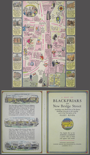
| Published | The Eighth Part of the Survey of London, a further Map of which will appear each month. [1947] |
| Dimensions | 255 x 190 mm |
| Notes |
One of a series of 17 pictographic maps of London, this example being a map of Blackfriars and New Bridge Street, the eighth part of the Survey of London described and illustrated by J.P.Sayer. Further maps continuing the survey were issued each month by Strand Magazine. The map is bordered by vignettes of the area, and like Sayer's other works, features numerous caricatures and notes of historic local interest. The verso features two eighteenth century views of the Fleet and Blackfriars Bridge, as well as a view of the New Bridge in 1947. J.P Sayer's work emerged from a growing trend of railway poster design in the Thirties which sought to incorporate historical information into the image. John Pearson Sayer (fl. 1930 - 1950) was an English artist and graphic designer. He provided the illustrations for the Motorist's Rhyme Book; a booklet produced by British Petroleum, which contorted popular nursery rhymes in order to sell its products. Sayer is best remembered for the posters that he designed for the Great Western Railway Company, and the uniquely pictographic style of his that emerged from these commissions. Works of Sayer's include posters of Oxford, Leamington Spa, Somerset, Cornwall, and the Cambrian Coast. Condition: Central vertical fold as issued. Binders holes to centre fold. Mounted in a double-sided mount. |
| Framing | mounted |
| Price | £75.00 |
| Stock ID | 40856 |