
| Method | Copper engraved with hand colour |
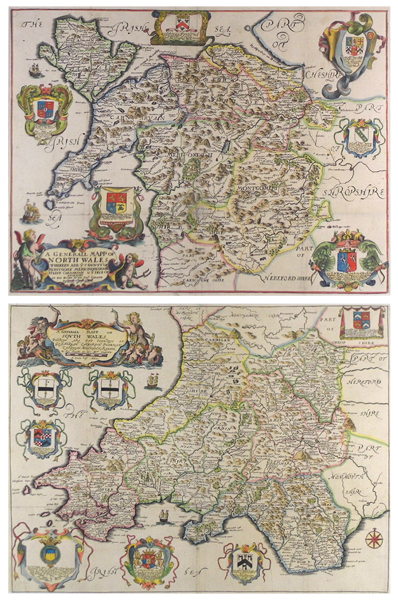
| Artist | Blome, Richard |
| Published | By Ric. Blome by his Masty. Comand. [London, c.1670] |
| Dimensions | North plate 338 x 452 mm, South plate 348 x 460 mm |
| Notes |
A pair of maps of North and South Wales, based on the cartography of Speed, from the first edition of 'Britannia', Blome's larger series of county maps. Blome's maps are often much maligned, due to their generally sketchy cartography and often naive decorative work and lettering, however they do include all the elements expected from a seventeenth century British map, including elaborately decorated cartouches, scales in English miles, crests and coats of arms, as well as dedications. In this example the titles are both enclosed in baroque cartouches. North Wales, featuring 'ye Countys of Montgomy, Merioneth, Denbigh, Fflint, Carnarvan & ye Isle of Anglesey,' is supported by a pair of cherubs, one carrying a garland of fruit, the other bearing a bident. South Wales, for the 'Countyes of Glamorgan, Carmarden, Pembrock, Cardigan, Brecknock, Radnor,' is flanked by a troop of cherubs carrying urns of water, as well as a pair of sea-gods, male and female, holding fish. Both maps feature numerous dedications to local nobles, with the arms of each appearing above. Blome apparently charged £4 each for the privilege, and the number of dedications shows that he had no shortage of subscribers. County borders and seacoasts are outlined in hand colour, and sailing ships populate the Welsh coasts in both maps. Richard Blome was one of the most active map-publishers of his day, working between about 1667 and 1705. His principal publications were the 'Geographical Description of the World', and two county atlases, the 'Britannia', published in 1673, and 'Speed's Maps Epitomiz'd', published in 1681. Blome first began engraving maps for his Geographical Description Of The Four Parts Of The World in 1667. The completed volume was in small folio, and contained 24 maps (plus one duplicated), engraved by Francis Lamb, Thomas Burnford, and Wenceslaus Hollar Blome has been heavily criticised as a plagiarist, but he lacked the capital to be innovative (as indeed did virtually all his contemporaries), and his output filled an important gap in the market. The 'Geographical Description' was the first new, and uniformly assembled, folio world atlas to be published in London since 1627, while the next folio world atlases appeared in the decade 1710-1720. Condition: Vertical and horizontal folds to both maps, as issued. Minor time toning to folds. Old tear repair to the westernmost section of Montgomeryshire on North plate. |
| Framing | mounted |
| Price | £775.00 |
| Stock ID | 42274 |