
| Method | Copper engraved with hand colour |
| Artist | Sayer, Robert |
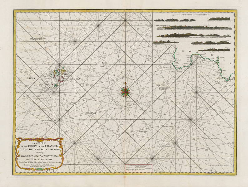
| Published | Revised by Mr. John Price, Chief Mate of the Kent, in 1786. London, Printed for R. Sayer No. 53, Fleet Street, as the Act directs 1st. Jany. 1789 |
| Dimensions | 505 x 680 mm |
| Notes |
A very large late eighteenth century sea chart of the Chops of the English Channel, encompassing the Isles of Scilly and the southernmost coastline of Cornwall. The map is criss-crossed with rhumb lines that radiate from a large and decorative compass rose at centre. Coastlines are outlined in hand colour, and beaches, reefs, and shoals are shaded. Depth soundings are provided, and descriptions of the sea bed are marked where known. In the top right corner, a series of illustrations show the appearance of key locations around Cape Cornwall, Lands End, and The Lizard as seen from a vessel at sea. In the bottom left, a decorative baroque cartouche encloses the title, while a smaller boxed cartouche at centre provides astronomical observations of latitude and longitude for The Lizard in Cornwall and St Agnes' Lights in the Scilly Islands. The imprimatur in the title cartouche attributes the map's revision to one John Price, Chief Mate of HMS Kent, which was sold out of service at Plymouth two years before this survey was completed. It is probable that the revision was based upon an earlier map created by the Royal Navy hydrographer Greenvile Collins. Robert Sayer (1725-1794) was a prolific English print and map seller, publisher, and engraver. Through his brother's wife, he became the manager of the printing house of John Overton, gradually taking over the business, with a concentration on atlases, maritime charts, cartography, and accounts of travel, exploration, and navigation. Sayer is also remembered for his engravings after paintings by Johan Zoffany, and the pair grew to be lifelong friends. Sayer was succeeded on his death by Laurie and Whittle. Condition: Central vertical fold, as issued. Minor creasing and foxing to central fold. Printers crease to right hand side of map. Old adhesive stain to verso, otherwise blank. |
| Framing | unmounted |
| Price | £750.00 |
| Stock ID | 51946 |