
| Method | Copper engraved |
| Artist | Ortelius, Abraham |
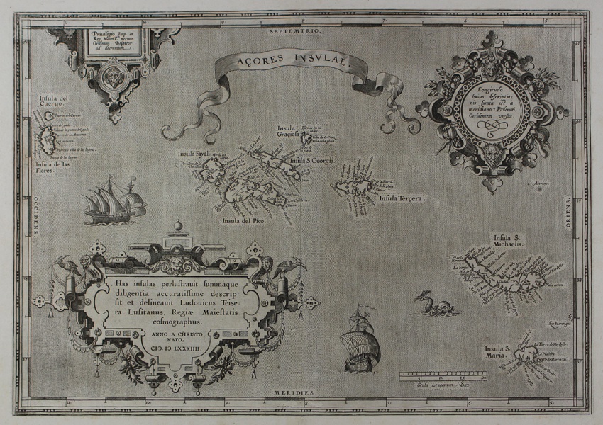
| Published | Privilegio Imp. et Reg. Maiest. necnon Ordinum Belgicor. ad decennium. [Antwerp, 1588] |
| Dimensions | 325 x 465 mm |
| Notes |
Ortelius' map of the Azores islands in the Atlantic, from the 1588 Spanish edition of the famous Theatrum Orbis Terrarum. The Azores, one of a number of sixteenth century locations for the Prime Meridian, are here shown 5° longitude west of the Ptolemaic meridian, as explained by textual notes in the beautiful and highly decorative cartouche in the top right corner of the map. The islands themselves, Cueruo, las Flores, Fayal, Graçiola, St George, Pico, Terçera, St Michael, and St Maria, are shown with their respective towns and settlements. Two large sailing ships and a sea monster occupy the waters of the Atlantic, and the map's title is enclosed in a large oriflamme. Another large cartouche in the bottom left corner, garlanded by fruit and ribbons, contains a description of the map's sources. Ortelius credits the Jesuit Portuguese cartographer Luis Teixeira with mapping the islands in 1584, the year in which this plate was first published. Teixeira's greatest cartographic achievement was his survey of Japan, also published by Ortelius, which became the standard reference for the country until Martino Martini's 1655 map. Abraham Ortelius (1527 -1598) was a Flemish cartographer, cosmographer, geographer and publisher and a contemporary of Gerard Mercator, with whom he travelled through Italy and France. Although it is Mercator who first used the word "Atlas" as a name for a collection of maps, it is Ortelius who is remembered as the creator of the first modern atlas. 'Theatrum Orbis Terrarum' was the first systematically collated set of maps by different map makers in a uniform format. Three Latin editions as well as a Dutch, French and German edition of 'Theatrum Orbis Terrarum' were published by 1572 and a further 25 editions printed before Ortelius' death in 1598. Several more were subsequently printed until around 1612. Ortelius is said to have been the first person to pose the question of the continents once being a single land mass before separating into their current positions. Condition: Central vertical fold, as issued. Old wormhole repair to central fold. Crossed arrows watermark. Spanish text on verso. |
| Framing | unmounted |
| Price | £650.00 |
| Stock ID | 45405 |