| Method | Copper engraved |
| Artist | Boisseau, Jean |
| Published | [Published by Jean Boisseau, Paris, 1643] |
| Dimensions | Image 130 x 187 mm |
| Notes |
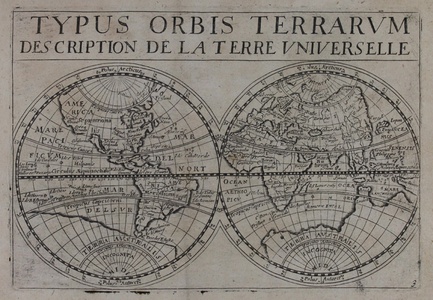
A rare world map from Jean Boisseau's 'Trésor des Cartes Geographique Des principaux Estats de L'Univers' first published in 1643. Boisseau's maps were also included in a composite text compiled for the education of the young future King Louis XIV. 'Trésor...' was one of the first original French world atlases, based on the maps of Jansson's edition of the Mercator-Hondius 'Atlas Minor'. The world map is finely detailed with a peculiar depiction of the west coast of North America influenced by previous maps by Van der Keere, with California as an island. Also, curiously, the north western tip of Terra Australis is entitled both 'Beach' and 'Lucach'[Locach], Marco Polo described Locach as a kingdom of gold, stating it was "so plentiful that no one who did not see it could believe it". Beach was in fact a mistranscription of Locach. This early printing features a blank printed Britain, without the delineation of England and Scotland. Boisseau's atlas was popular and therefore reprinted in several editions by Louis Boissevin, Nicolas Picard, Claude Jollain, Pierre du Val and others. Jean Boisseau (fl. 1637-1657) was a Parisian mapmaker and publisher. Shirley 359 Condition: Good impression. Ink offset to plate mark. |
| Framing | mounted |
| Price | £700.00 |
| Stock ID | 44488 |

