
| Method | Copper engraved |
| Artist | Speed, John |
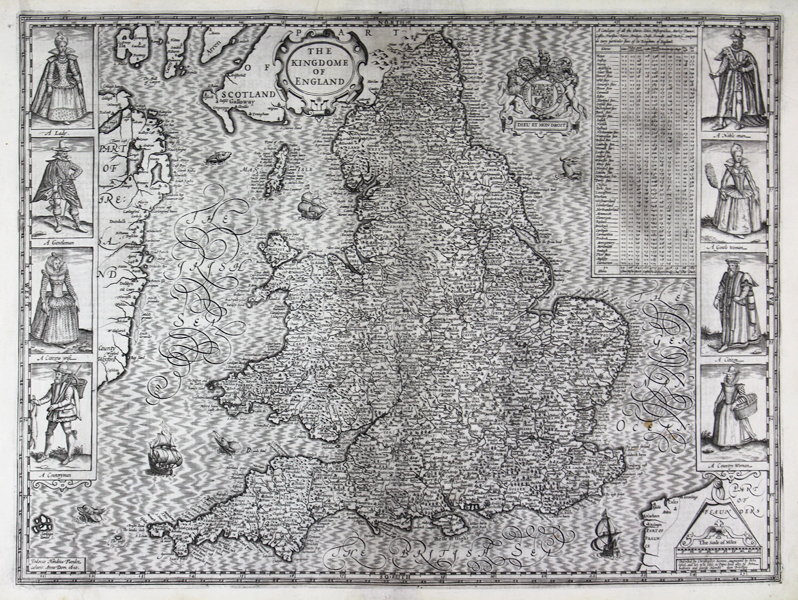
| Published | Jodocus Hondius Flander. caelavit. Anno Dom. 1610. Described by Christopher Saxton, augmented by John Speed, and are to be solde in Popes head alley by John Sudbury and George Humble Cum Privilegio. [London, 1611] |
| Dimensions | 382 x 510 mm |
| Notes |
A crisp and dark impression of the first edition of Speed's map of England and Wales, from the Theatre of the Empire of Great Britaine. The seas surrounding the country are populated by sea monsters and sailing ships, and the title is enclosed in a strapwork oval cartouche. To the right, the Royal coat of arms is shown alongside a large table detailing the number of cities, bishoprics, market towns, castles, parish churches, rivers, bridges, chases, forests, and parks per county. The map is flanked by images of the costumes of a nobleman, a gentleman, a citizen, and a countryman, along with their wives. The map was published in the first edition of John Speed's atlas in 1612 with a plate engraved by Jodocus Hondius. By 1630 the original plate had become worn and a new one was engraved by Abraham Goos and this was amended and updated in 1646. The 1646 date was added at lower left and appeared in editions thereafter. John Speed (1552-1629) is the most famous of all English cartographers primarily as a result of The Theatre of the Empire of Great Britaine, the first atlas of the British Isles. The maps from this atlas are the best known and most sought-after of all county maps. The maps were derived mainly from the earlier prototypes of Christopher Saxton and John Norden but with notable improvements including parish "Hundreds" and county boundaries, town plans and embellishments such as the coats of arms of local Earls, Dukes, and the Royal Household. The maps are famed for their borders consisting of local inhabitants in national costume and panoramic vignette views of major cities and towns. An added feature is that regular atlas copies have English text printed on the reverse, giving a charming description of life in the early seventeenth century of the region. The overall effect produced very decorative, attractive and informative maps. For the publication of his prestigious atlas, Speed turned to the most successful London print-sellers of the day, John Sudbury and George Humble. William Camden introduced the leading Flemish engraver, Jodocus Hondius Sr. to John Speed in 1607 because first choice engraver William Rogers had died a few years earlier. Work commenced with the printed proofs being sent back and forth between London and Amsterdam for correction and was finally sent to London in 1611 for publication. The work was an immediate success, with the maps themselves being printed for the next 150 years. Speed was born in 1552 at Farndon, Cheshire. Like his father before him he was a tailor by trade, but around 1582 he moved to London. During his spare time Speed pursued his interests of history and cartography and in 1595 his first map of Canaan was published in the "Biblical Times". This raised his profile and he soon came to the attention of poet and dramatist Sir Fulke Greville a prominent figure in the court of Queen Elizabeth. Greville as Treasurer of the Royal Navy gave Speed an appointment in the Customs Service giving him a steady income and time to pursue cartography. Through his work he became a member of such learned societies as the Society of Antiquaries and associated with the likes of William Camden, Robert Cotton, and William Lambarde. He died in 1629 at the age of seventy-seven. Condition: Strong dark impression. Central vertical fold as issued. Professionally repaired tear to bottom of central fold. Professionally backed with archival tissue. Old sepia ink stains off the Essex coast, and along bottom margin. Printer's creases to top right corner of sheet and horizontally through 'A citizen's wife'. Latin text on verso. |
| Framing | unmounted |
| Price | £2,400.00 |
| Stock ID | 49037 |