
| Method | Copper engraved |
| Artist | Ogilby, John after Dapper, Olfert |
| Published | [London, 1670] |
| Dimensions | 230 x 337 mm |
| Notes |
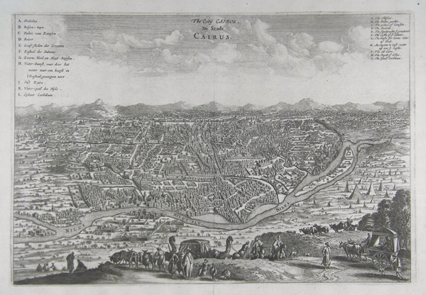
A fine bird's-eye view of the ancient city of Cairo, originally featured in Dapper's 'Description of Africa', and heavily based upon the 1549 view of Cairo by Venetian printmaker Matteo Pagono. This striking view of Cairo places the dense city in the centre, surrounded by open landscape. Set to the right of the city, past the River Nile, are depictions of the Pyramids and the Sphinx. In the immediate foreground, several travellers can be seen upon a hilltop that overlooks the city. With them are various animals, including cattle and camels. Two lettered keys are featured, one in Dutch in the upper left corner, and the other, an English translation in the upper right. The view was featured in John Ogilby's English edition of Olfert Dapper's 'Description of Africa'. Olfert Dapper's 'Description of Africa' was an ethnographic book which offered a detailed description of the parts of Africa known to Europeans in the mid-seventeenth century. Despite the work being regarded as one of the most important and detailed seventeenth-century publications on Africa, Dapper himself never actually visited the continent. Instead, he relied on the reports of Jesuit missionaries and Dutch explorers. Dapper's 'Description of Africa' was first published in 1668 by Jacob van Meurs in Amsterdam, with a second Dutch edition appearing in 1676. In 1670, a German translation of the publication was issued, and in the same year, an English translation, which is generally attributed to John Ogilby. A French edition was published in 1676, although it was not as true to the original as the other translations. Olfert Dapper (1636 - 1689) was a Dutch physician and writer. Despite never travelling outside of the Netherlands, Dapper was a writer of world history and geography. John Ogilby (1600-1676) was a Scottish cartographer and publisher. Ogilby is perhaps best known for his series of road-maps entitled the "Britannia", which was the first road-atlas of any country, published in 1675. Condition: Vertical centre fold as issued. A few small tears ton edges of sheet, and a small puncture hole in upper right margin. |
| Framing | unmounted |
| Price | £300.00 |
| Stock ID | 41432 |