
| Method | Woodcut |
| Artist | Münster, Sebastian |
| Published | [Basel c. 1588] |
| Dimensions | 315 x 358 mm |
| Notes |
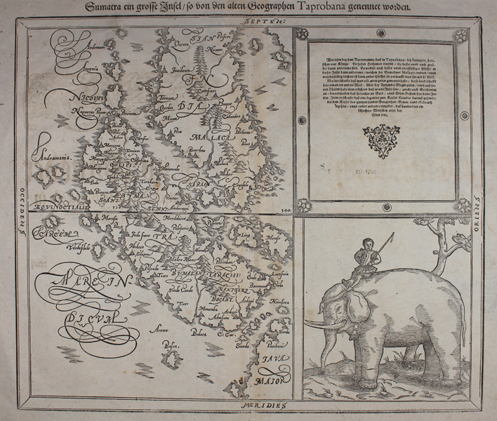
Munster's map of Sumatra and the Malay peninsula from a German edition of the Cosmographia. The map equates Sumatra with the classical island of Taprobana, superseding an earlier map from Munster's edition of Ptolemy's Geographia which featured an island much more closely resembling Sri Lanka. Considering its age, the map is relatively accurate in its portrayal of the region, particularly the place names of coastal settlements on the west coast of the Malay peninsula. In the bottom right corner, part of Java can be seen. Much of the right hand side of the plate is taken up by a large illustration of a mahout on an elephant, and a descriptive text in German discussing the classical Taprobana, including references to Pliny and the journeys of Alexander the Great. Sebastian Münster (20th January 1488 - 26th May 1552) was a German cartographer, cosmographer, and theologian. A gifted scholar of Hebraic, Münster originally joined the Franciscans, but left the order in favour of the Lutheran Church. He was appointed to the University of Basel in 1529, and published a number of works in Latin, Greek, and Hebrew. His most celebrated works are his Latin edition of Ptolemy's Geographia in 1540, and the Cosmographia in 1544. The Cosmographia was the earliest German description of the world, an ambitious work of 6 volumes published in numerous editions in German, Latin, French, Italian, and Czech. Henricus Petrus (1508-1579) was a German printer and published, whose print-works in Basel produced some of the most influential works of the German Renaissance, including Copernicus' De revolutionibus orbium coelestium and Munster's Cosmographia. Condition: Central vertical fold as issued. Minor creasing to corners of sheet. Printers crease in centre of plate. German letterpress title on verso. |
| Framing | unmounted |
| Price | £325.00 |
| Stock ID | 48398 |