
| Method | Copper engraved |
| Artist | Ogilby, John after Dapper, Olfert |
| Published | [London, 1670] |
| Dimensions | 244 x 311 mm |
| Notes |
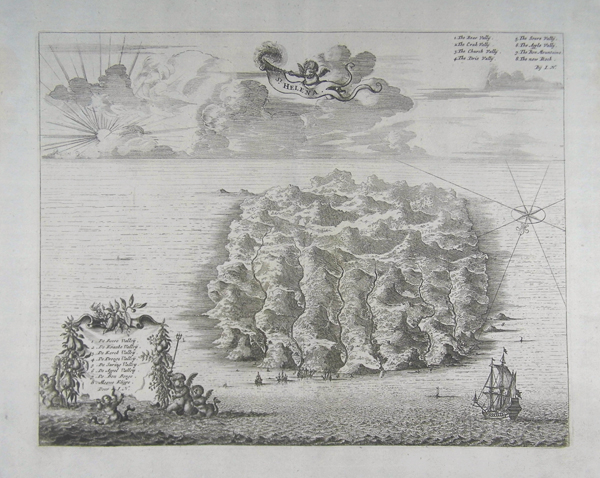
A plan of St. Helena, oriented with north towards the lower left. In the lower left corner, a numbered key, in Dutch, is set within a highly decorative cartouche. An English translation of the key is present in the upper right corner. The plan was featured in John Ogilby's English edition of Olfert Dapper's 'Description of Africa'. Olfert Dapper's 'Description of Africa' was an ethnographic book which offered a detailed description of the parts of Africa known to Europeans in the mid-seventeenth century. Despite the work being regarded as one of the most important and detailed seventeenth-century publications on Africa, Dapper himself never actually visited the continent. Instead, he relied on the reports of Jesuit missionaries and Dutch explorers. Dapper's 'Description of Africa' was first published in 1668 by Jacob van Meurs in Amsterdam, with a second Dutch edition appearing in 1676. In 1670, a German translation of the publication was issued, and in the same year, an English translation, which is generally attributed to John Ogilby. A French edition was published in 1676, although it was not as true to the original as the other translations. Olfert Dapper (1636 - 1689) was a Dutch physician and writer. Despite never travelling outside of the Netherlands, Dapper was a writer of world history and geography. John Ogilby (1600-1676) was a Scottish cartographer and publisher. Ogilby is perhaps best known for his series of road-maps entitled the "Britannia", which was the first road-atlas of any country, published in 1675. Condition: Vertical centre fold as issued. Some light creasing and discolouration to margins. |
| Framing | unmounted |
| Price | £200.00 |
| Stock ID | 41421 |