
| Method | Chromolithograph |
| Artist | [Anonymous] |
| Published | [Harmsworth's New Atlas, London, c.1920] |
| Dimensions | 330 x 215 mm |
| Notes |
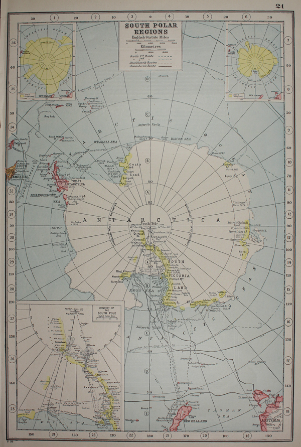
An early twentieth century colour printed map of the South Pole, from Harmsworth's New Atlas. The map is centred on the South Pole proper, with the key voyages of exploration shown as solid, dotted or dashed lines and marked with names and dates. A dashed line running into the Arctic Ocean shows the approximate limit of the pack ice. Three inset maps provide details on the 'Conquest of the South Pole' as well as the extent of unexplored territory in 1775 and 1845. On the verso, a descriptive text is enclosed by a large decorative border in which are featured photographic portraits of key figures of antarctic exploration and vignettes of antarctic landscapes. Harmsworth's New Atlas was one of a number of atlases published by Harmsworth's Amalgamated Press, intended to expand geographic knowledge beyond the company's highly popular and successful Universal Encyclopaedia. Alfred Harmsworth, 1st Viscount Northcliffe (1865-1922) was the most powerful and successful newspaper magnate of his era. Owner, among others, of the Daily Mail and the Daily Mirror, Harmsworth's publishing empire aimed to capture the interest of the working classes, and in many ways, was the progenitor of the sensationalist journalism that dominates today's much of the present day's print media. In additon to occupying a central role in the propaganda of the First World War, Harmsworth's empire also stretched to popular educational works aimed at the middle and working classes, particularly periodical geographical works. Condition: Trimmed close to border on left margin, without loss to map. Minor time toning to edges of sheet. |
| Framing | unmounted |
| Price | £40.00 |
| Stock ID | 49159 |