
| Method | Copper engraved with early hand colour |
| Artist | Overton, Henry |
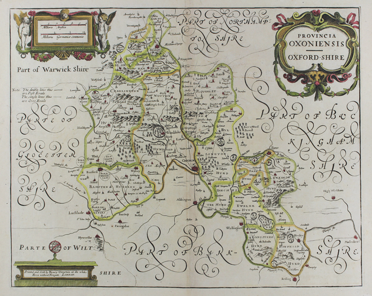
| Published | Printed and Sold by Henry Overton at the white Horse without Newgate, London [c.1713] |
| Dimensions | 364 x 460 mm |
| Notes |
A rare map of Oxfordshire, from Overton's 'England Fully Described in a Compleatt Sett of Mapps of ye County's of England and Wales.' Although an early eighteenth century printing, this plate is a very close copy by an unknown engraver of the Oxfordshire map from Jansson's 'Appendix' to the Mercator-Hondius atlas, published in 1644, and the last published derivative of this county map. The obvious alteration is the addition of the county's road network, with Post Roads and Cross Roads illustrated. Like the early Jansson printing, the map features decorative cartouches, enclosing the title, the publisher's details, and a scale in English and German miles flanked by cherubs and garlands. The county hundreds are outlined in hand-colour, and principal cities and towns are picked out in red. Henry Overton (1676 - 1751) was a British engraver, publisher, mapmaker, and printseller. The son of the mapseller John Overton, and brother of Philip Overton, Henry set up his own business in 1707 in partnership with John Hoole. His earlier maps were largely based on acquired plates engraved by Sutton Nicholls, John Speed, and Blaeu. In addition to his own works, he also published revised editions of Speed's Atlas, as well as David Loggan's views of the colleges and public buildings of the Universities of Oxford and Cambridge. Condition: Pressed central vertical fold, as issued. Time toning and foxing to edges of sheet, and central fold. Light manuscript annotations in sepia ink to blank space above Ploughley Hundred. Blank on verso. |
| Framing | unmounted |
| Price | £1,200.00 |
| Stock ID | 49709 |