
| Method | Copper engraved |
| Artist | Ortelius, Abraham |
| Published | [Antwerp, 1575] |
| Dimensions | 375 x 438 mm |
| Notes |
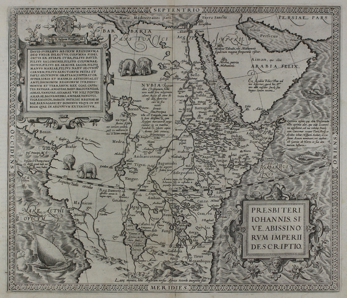
The celebrated map of the fictional Kingdom of Prester John in Abyssinia, central Africa, designed by Ortelius himself, from the 1575 Latin edition of the famous Theatrum Orbis Terrarum. The Abyssinian kingdom features numerous cities along the course of the Nile and its tributaries, as well as depictions of two large lakes, Zaire and Zaflan, roughly equating to the positions of present day Lakes Victoria and Tanganyika, and above the so-called Mountains of the Moon. The neighbouring regions and kingdoms of Persia, the Arabian Peninsula, Egypt, Barbaria, Nubia, and Benin are also depicted. The cities of Mecca, Medina, Jerusalem, Cairo, Alexandria, and Tripoli are clearly labelled. The map is very heavily ornamented, with pairs of elephants in Nubia and the west Congo, a large single-sailed warship probably representing an Arab dhow off the west African coast, a pair of sea monsters east of Abyssinia and Arabia, a dashed equatorial line, and a pair of strapwork cartouches. The first of these cartouches, containing the title of the map in Latin, is garlanded with African fruits and a pair of royal masks. The second, containing a lengthy honorific purporting to be that of Prester John himself, is bordered by floral emblems of the kingdom, and John's coat of arms, a crest emblazoned with a Lion holding a Nestorian crucifix. The verso text in Latin provides a history of the Kingdom of Prester John, and western attempts to contact this supposed hero of Christianity. Prester John was a mythical Christian king popular in European chronicles and traditions from the 12th to the 17th century. John was supposedly descended from David, or in some traditions, the Three Magi, and regarded as an important defence against the barbarians, and a potential ally for the Crusades. He was said to rule over a Nestorian Christian nation lost amid the Muslims and pagans of the Orient. Originally believing him to be somewhere in the Middle East, Pope Alexander III sent John a letter in 1177 begging him to help against the Mongols, but his messenger never returned. As Polo and other travellers opened the East without finding him, Prester John's kingdom retreated into the unknown. Although Waldseemüller's maps of 1507 place him in India, Fries moved him to Africa in 1522. Eventually Portuguese explorers convinced themselves that they had found him in Ethiopia, where he resides on this map. Abraham Ortelius (1527 -1598) was a Flemish cartographer, cosmographer, geographer and publisher and a contemporary of Gerard Mercator, with whom he travelled through Italy and France. Although it is Mercator who first used the word "Atlas" as a name for a collection of maps, it is Ortelius who is remembered as the creator of the first modern atlas. Theatrum Orbis Terrarum was the first systematically collated set of maps by different map makers in a uniform format. Three Latin editions as well as a Dutch, French and German edition of Theatrum Orbis Terrarum were published by 1572 and a further 25 editions printed before Ortelius' death in 1598. Several more were subsequently printed until around 1612. Ortelius is said to have been the first person to pose the question of the continents once being a single land mass before seperating into their current positions. Condition: Strong dark early impression with full margins. Central vertical fold as issued. Repaired tear to bottom of central fold. Manuscript page number '93' on verso. Crossed arrows watermark. Latin text on verso. |
| Framing | framed |
| Price | £1,200.00 |
| Stock ID | 45408 |