
| Method | Copper engraved |
| Artist | Mercator, Gerard and Hondius, Jodocus |
| Published | [Amsterdam, c.1610] |
| Dimensions | 135 x 185 mm |
| Notes |
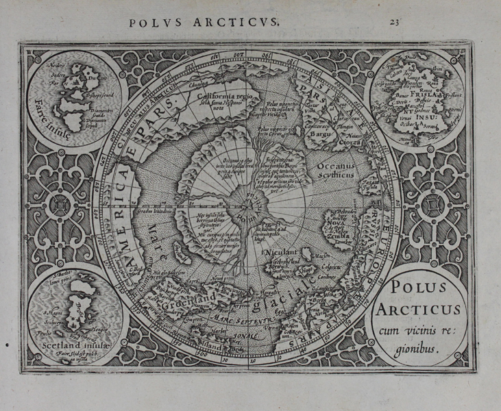
A decorative miniature map of the Arctic Circle, from a Latin edition of the Mercator-Hondius Atlas Minor. The map, recreating the inset roundel map of the Polar Regions featured in the bottom left of Mercator's landmark world map of 1569, shows the North Pole as a high mountain in a frozen sea surrounded by four putative islands. Surrounding this, the northern reaches of Russia, Scandinavia, Iceland, Greenland, and America can be seen. California is shown as a very large lobe at the top of the Americas, and one of the Polar islands features a descriptive note that it is inhabited by pygmies. Surrounding the centre sphere are four smaller roundels, one of which contains the title, while the other three show maps of the phantom island of Frisland, the Faroe Isles, and the Shetlands. Blank spaces are further embellished by an elaborate fretwork pattern. Gerard Mercator (1512 - 1594) originally a student of philosophy was one of the most renowned cosmographers and geographers of the 16th century, as well as an accomplished scientific instrument maker. He is most famous for introducing Mercators Projection, a system which allowed navigators to plot the same constant compass bearing on a flat map. His first maps were published in 1537 (Palestine), and 1538 (a map of the world), although his main occupation at this time was globe-making. He later moved to Duisburg, in Germany, where he produced his outstanding wall maps of Europe and of Britain. In 1569 he published his masterpiece, the twenty-one-sheet map of the world, constructed on Mercator's projection. His Atlas, sive Cosmographicae Meditationes de Fabrica Mundi, was completed by his son Rumold and published in 1595. After Rumold's death in 1599, the plates for the atlas were published by Gerard Jr. Following his death in 1604, the printing stock was bought at auction by Jodocus Hondius, and re-issued well into the seventeenth century. Jodocus Hondius (14th October 1563 - 12th February 1612) was a Dutch Flemish cartographer, engraver, and publisher. Hondius is most famous for reviving the primacy of the work of Gerard Mercator, through the publication of his Atlas, and the smaller Atlas Minor, in the early seventeenth century, at a time when cartography was largely dominated by Ortelius' Theatrum Orbis Terrarum. The Mercator-Hondius Atlas was composed of maps pulled from plates Hondius had purchased from Mercator's grandson, as well as thirty-six new plates Hondius commissioned, and in many cases engraved, himself. He is also believed to have been the chief engraver of the plates for John Speed's Theatre of the Empire of Great Britaine. Following his death, he was succeeded by his sons, Jodocus the Younger and Henricus, as well as his son in law Jan Jansson. Condition: Small wormhole to bottom left corner of sheet, not affecting map. Minor time toning to edges of sheet. Latin descriptive text and old manuscript notation in sepia ink on verso. |
| Framing | unmounted |
| Price | £500.00 |
| Stock ID | 47347 |