
| Method | Copper engraved with hand colour |
| Artist | Moll, Herman |
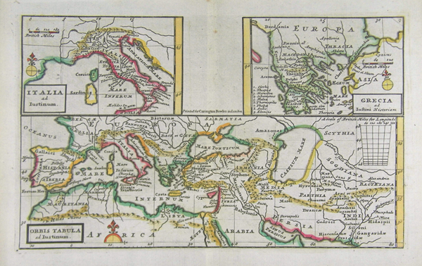
| Published | London: Printed for the Proprietor Carington Bowles, at his Map and Print Warehouse, No. 69, St Paul's Church Yard. MDCCLXXXIV [1784] |
| Dimensions | 154 x 256 mm |
| Notes |
Three maps on a single sheet, depicting the Ancient World, Italy, and Greece, from Bowles' Geographia Classica, or the Geography of the Ancients, as contained in the Greek and Latin Classics. The bottom half of the plate shows the Roman world as it existed in the 2nd century AD, with particular reference to the extent of Parthian territory in the East. Above are two smaller boxed maps above depicting Italy and Greece. Sea coasts and provincial borders are outlined in hand colour, as are mountain ranges. The map was designed to accompany editions of the work of the Roman historian Marcus Iunianius Iustinus, known colloquially as Justin. Very little is known of Justin beyond his work, itself an epitome of an earlier Augustan historian, Gnaeus Pompeius Trogus. The date of his floruit is traditionally placed in the 2nd century AD, though could be as late as the 4th century AD. Justin's epitome was very popular in the Medieval era, and a major source for descriptions of the Roman period in early printed histories, particularly the Nuremberg Chronicle and Munster's Cosmographia. Bowles' Geographia Classica, or the Geography of the Ancients, as contained in the Greek and Latin Classics was undertaken by Herman Moll as a supplement to the many eighteenth century editions of Greek and Latin classics published by Carington Bowles and his contemporaries. Most editions contained a total of 32 maps in an arrangement similar to Ortelius' famous Parergon, depicting the kingdoms and provinces of the Greek and Roman world, elucidating particular texts such as 'Caesar's Gaul' or the 'Journeys of Aeneas,' and including a number of biblical maps. Unlike the Parergon, which was accompanied by Ortelius' copious notes and commentary, Moll's Geographia Classica contained no explanatory text, with the frontis instead explaining that the atlas was 'Principally designed for the Use of Schools, as being accomodated for the more easy and clear Understanding of the Ancient Authors.' The list as given by Moll included Homer, Herodotus, Justin, Virgil, Ovid, Florus, Nepos, Caesar, Livy, Lucan, and Plutarch. Herman Moll (c.1654-1732) was born in Germany and came to England in the 1670s. He worked as an independent cartographer and geographer, and traded as a map publisher and seller for two years, and then worked for other publishers. Moll established his own business and eventually dominated the early eighteenth century map trade. He produced many maps and atlases of England, Wales, Scotland and Ireland. His county maps were all boldly engraved in a heavy style. Moll was also an active member in academic and intellectual circles, being a close associate of Daniel Defoe, Robert Boyle, Robert Hooke, and, most importantly for his cartographic career, the pre-eminent English explorer of the era, William Dampier. Condition: Central vertical fold as issued. Minor time toning and foxing to top of centre fold, not affecting plate. |
| Framing | mounted |
| Price | £125.00 |
| Stock ID | 41358 |