
| Method | Electrotype |
| Artist | Baker, Benjamin after Colby, Thomas Frederick |
| Published | Published at the Tower of London, 1st May 1830, by Lieut. Colonel Colby of the Royal Engineers. Engraved at the Ordnance Map Office in the Tower under the direction of Lieut. Colonel Colby by Benjm. Baker & Assistants_The Writing by Ebenr. Bourne. Printed from an Electrotype [c.1850] |
| Dimensions | 640 x 760 mm |
| Notes |
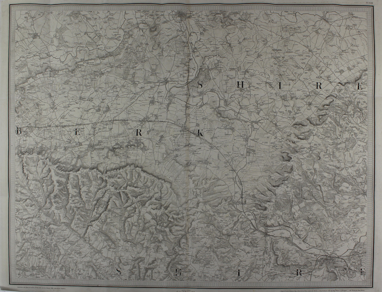
A large-scale folding survey map of southern Oxfordshire and Berkshire, from the Ordnance Survey of Great Britain. The map stretches from Oxford in the north to Reading in the south, and encompasses the Vale of the White Horse in the west to Henley in the east. The original map was engraved and published in 1830, though this is a later printing taken from an electrotype of the original plate, likely published just before the map was updated in the 1860s to include the expanded rail network. In this 1830 example, Oxford is served only by a branch line from Didcot, with the line terminating at a station to the south of Folly bridge. The Ordnance Survey or "OS" is the national mapping agency of Great Britain. The agency provides the most recent and accurate geographic data of Great Britain to the government, businesses and individuals. It was officially founded in 1791, but has even earlier roots. The government first ordered the department of Defence to map the Scottish Highlands after a rebellion took place there in 1745. When the French Revolution started, a survey of the English south coast was ordered. These first surveys were meant to support strategic military planning. William Roy (1726 - 1790), an engineer who worked for the government on these first surveys, became convinced that accurate mapping of Great Britain in its entirety was needed. His vision greatly influenced the foundation of the Ordnance Survey. Between 1842 and 1893, the entire country was surveyed, and would be revised every twenty years. During the 1850's, there was a debate about the most efficient scale to use for ordnance maps, better known as the "Battle of the Scales". The scale of 25 inches to the mile became the standard scale used to map urban as well as rural areas from 1855 onwards, and is still used today. The less detailed scale of six inches to the mile were used only for some uncultivated rural areas, moorlands or mountainous areas. Lt. Col. Thomas Frederick Colby (1784-1852) was an officer in the Royal Engineers and a Director of the Ordnance Survey. After sustaining an injury in a shooting accident, he began surveying and cartographical work with the OS Director General Mudge, eventually being nominated for Mudge's successor by the Duke of Wellington. He was made a Fellow of the Royal Society, the Geographical Society, and the Astronomical Society, and played a key role in the Surveys of Scotland and Ireland. Condition: Printed over two sheets and joined vertically at centre. Vertical and horizontal folds as issued. Minor tears to folds. Otherwise a crisp impression on clean heavy paper. |
| Framing | unmounted |
| Price | £65.00 |
| Stock ID | 49692 |