
| Method | Steel engraved with original hand colour |
| Artist | Rapkin, John |
| Published | John Tallis & Company, London & New York, 1851. |
| Dimensions | 253 x 328 mm |
| Notes |
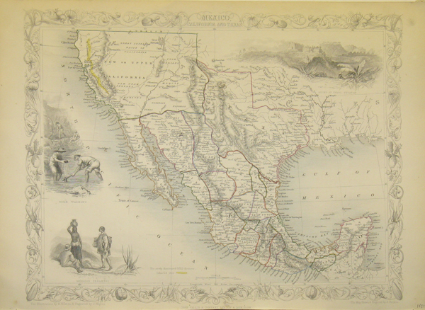
Decorative map of the Texas, California and the Southwest,featuring Texas in its Republic configuration, with stovepipe reaching to Wyoming and Colorado. Upper California is shown with the Gold Regions highlighted in gold, a pre-Gadsden border with Mexico and a host of other contemporary details. Numerous Indian Tribes named throughout the Southwest. Early routes through Texas and the West are shown. Includes a number of forts and outposts in Texas and Upper California. John Tallis was a British publisher and one of the most popular cartographers of the 19th Century. Tallis maps were highly valued for their accuracy, but perhaps more so for their charming vignettes and ornamentation. Engraved by John Rapkin, these maps were praised by the New York Sun as "the most accurate and most splendid publication of the kind ever issued". The Bristol Times observed that Mr. Tallis maps "are not only critically correct, but are accompanied with elegant and appropriate engravings illustrative of the manners and costumes of the different countries." John Rapkin was an engraver and mapmaker active in Britain in the mid-nineteenth century. He drew and engraved the maps for John Tallis' 'The Illustrated Atlas and Modern History of the World' (1845-51), which was later re-issued by the London Printing and Publishing Company. He also drew and engraved maps for R. Montgomery Martin's 'British Colonies, their history' (1849), and Wright's 'Universal Pronouncing Dictionary' (c.1850). |
| Framing | unmounted |
| Price | £250.00 |
| Stock ID | 17883 |