
| Method | Copper engraved with hand colour |
| Artist | van den Keere, Pieter |
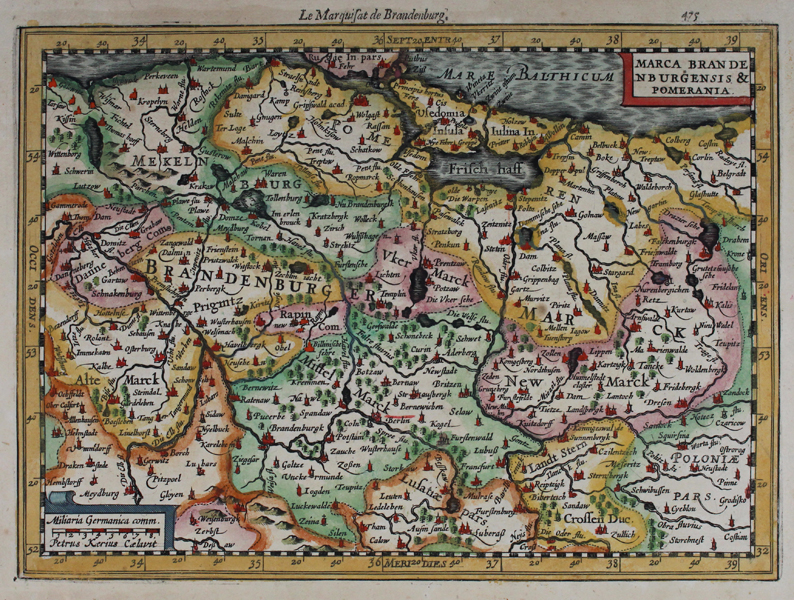
| Published | Petrus Kerius Caelavit [Jan Jansson. Amsterdam, c. 1630] |
| Dimensions | 181 x 250 mm |
| Notes |
A decorative miniature map of northern Germany, extending to the Baltic Sea. Engraved by Keere for the Jansson editions of the Mercator-Hondius 'Atlas Minor'. Hills, mountain ranges and forests have been included, with principal towns picked out in red. Riverways have been illustrated in fine detail. French text to verso. In 1628 Jan Jansson published a new edition of Gerard Mercator's 'Atlas Minor', which had first appeared in 1607. A large number of new miniature plates were engraved, mainly by Abraham Goos and Pieter Van den Keere, this atlas was published in nine editions between 1628 and 1651. Pieter van den Keere (1571- c.1646), also known frequently as Petrus Kaerius, came to England in 1584, as a Protestant refugee from his home town of Ghent with his sister Colette, who married Jodocus Hondius, in 1587. It was probably from Hondius that Keere learned to engrave. Both engravers left London in 1593 to settle in Amsterdam. Johannes Janssonius (1588 - 1664) was a famed cartographer and print publisher. More commonly known as Jan Jansson, he was born in Arnhem where his father, Jan Janszoon the Elder, was a bookseller and publisher. In 1612 he married the daughter of the cartographer and publisher Jodocus Hondius, and then set up in business in Amsterdam as a book publisher. In 1616 he published his first maps of France and Italy and from then onwards, produced a very large number of maps which went some way to rival those of the Blaeu family, who held a virtual monopoly over the industry. From about 1630 to 1638 he was in partnership with his brother-in-law, Henricus Hondius, issuing further editions of the Mercator/Hondius atlases to which his name was added. On the death of Hondius he took over the business, expanding the atlas still further, until eventually he published an eleven volume Atlas Major on a scale similar to Johannes Blaeu's magnum opus. After Jansson's death, his heirs published a number of maps in the Atlas Contractus of 1666, and, later still, many of the plates of his British maps were acquired by Pieter Schenk and Gerard Valck, who published them again in 1683 as separate maps. Condition: Time toning and light foxing. |
| Framing | unmounted |
| Price | £80.00 |
| Stock ID | 45528 |