
| Method | Copper engraved with hand colour |
| Artist | after Jansson, Jan |
| Published | [c.1685] |
| Dimensions | 355 x 475 mm |
| Notes |
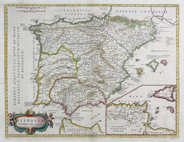
A very unusual and rare late seventeenth century map of Spain and Portugal in the Roman era, either a reworked late issue of Jan Jansson's map of the same title, or an outright copy. The main details of the map are a very close match to the example engraved by Jansson after Ortelius' famous Parergon map of the region, with the Spanish peninsula divided into the three imperial provinces of Lusitania, Baetica, and Hispania Tarraconensis. The Balearic islands are shown, as is the northern tip of Africa at the Straits of Gibraltar. The title is enclosed in a baroque cartouche flanked by putti, very similar to other examples by Jansson, but replacing the pediment cartouche in his normal version of this map. Where Jansson's original has a small inset map of the region of Cadiz and a large list of places of uncertain location, this example has a large inset map of Sicily and the Roman Africa Province (modern Tunisia). The decorative elements of the map's border are also here removed. Johannes Janssonius (1588 - 1664) was a famed cartographer and print publisher. More commonly known as Jan Jansson, he was born in Arnhem where his father, Jan Janszoon the Elder, was a bookseller and publisher. In 1612 he married the daughter of the cartographer and publisher Jodocus Hondius, and then set up in business in Amsterdam as a book publisher. In 1616 he published his first maps of France and Italy and from then onwards, produced a very large number of maps which went some way to rival those of the Blaeu family, who held a virtual monopoly over the industry. From about 1630 to 1638 he was in partnership with his brother-in-law, Henricus Hondius, issuing further editions of the Mercator/Hondius atlases to which his name was added. On the death of Hondius he took over the business, expanding the atlas still further, until eventually he published an eleven volume Atlas Major on a scale similar to Johannes Blaeu's magnum opus. After Jansson's death, his heirs published a number of maps in the Atlas Contractus of 1666, and, later still, many of the plates of his British maps were acquired by Pieter Schenk and Gerard Valck, who published them again in 1683 as separate maps. Condition: Vertical folds, as issued. Repaired tears to margins. Blank on verso. |
| Framing | unmounted |
| Price | £500.00 |
| Stock ID | 48950 |