
| Method | Steel engraved with original hand colour |
| Artist | Johnston, William and Johnston, Alexander Keith |
| Published | W. & A.K. Johnston, Edinr. William Blackwood & Sons. Edinburgh, & London. [c.1850] |
| Dimensions | 210 x 265 mm |
| Notes |
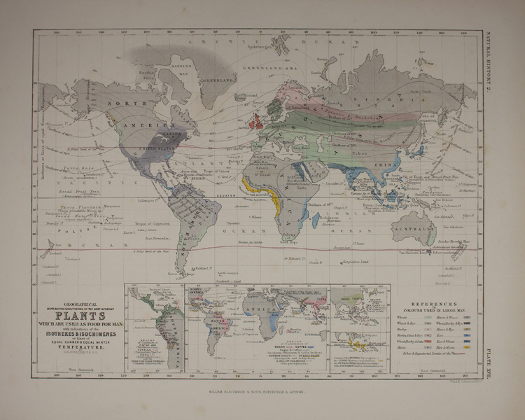
A detailed mid-nineteenth century world map, showing the distribution of the principal plants used as food crops, published by William Blackwood for W. & A.K. Johnston's Physical Atlas of Natural Phenomena. The map provides a fascinating snapshot of global food production during the Victorian era. The map is colour coded in original wash colour, corresponding to the main grains and pulses grown in each region, with different colours representing different combinations. For example, at the time of printing, the British Isles were the only place shown on the map as having combined production of Wheat, Barley, & Oats, while west Africa was the only region where Rice & Maize are grown together. Other staples, such as potatoes, plantains, yams, and bread fruit are included as text annotations rather than colour coded. The map also features two red lines marking the northern and southern limits of viticulture at the time. Along the bottom margin, a group of four inset maps show the production of regional specialities, including Cacao, Vanilla, Coca, Sugar, Coffee, Cotton, Tea, Pepper, Clove, Nutmeg, and Cinnamon. W. & A.K. Johnston was one of the major publishing houses of the 19th century. Founded by William and Alexander Keith (1804-1871) Johnston, they apprenticed under the Scottish publisher and globe maker James Kirkwood in Edinburgh. They later went on to establish their own business in the city, expanding their output into not only maps, but atlases, guide books, globes and educational posters. Alexander's son, also called Alexander Keith Johnston (1844-1879), continued the business, as well as authoring various geographical works of his own. The business continued to publish material under the Johnston name until the 1960s. Condition: Minor time toning to edges of sheet. Chipping and printer's creases to bottom margin, not affecting map. Small ink stain to left margin, not affecting map. Blank on verso. Includes three double-sided sheets of accompanying descriptive text. |
| Framing | unmounted |
| Price | £75.00 |
| Stock ID | 49154 |