
| Method | Copper engraved with early hand colour |
| Artist | Ortelius, Abraham & Vrints, Johannes Baptista |
| Published | Ioannes Baptista Urints excudit [1608] |
| Dimensions | 395 x 480 mm |
| Notes |
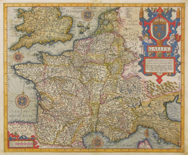
Inscription reads: 'Geographica Galliae descriptio, de integro plurimis in locis emendata ac Regionum limitibus distincta; auctore Petro Plantio.'Quisquid terrarum Rheno, Alpibus, mari Mediterraneo, Pyrennais montibus, oceano Aquitanico Britannico et Germanico clauditur; communi nomine Latinis Gallia appellatur; quibus limitibus potentissimum Francorum regnum, Sabaudia, Burgundiae comitatus, Helvetia, Alsatia, Lotharingia, inferior Germania, et quaedam aliae regiones hodie continentur.' A finely engraved and detailed map of France, with early hand colouring and exhibiting numerous decorative flourishes. Part of the famous Theatrum Orbis Terrarum, Ortelius' map of France took as a key source the map produced in 1592 by Petrus Plancius, also published by Urints. Attractively decorated in early hand colour, the map plots numerous French towns and cities, as well as listing the traditional regions of various Celtic tribes. Three ships engage in a naval battle in the English Channel, and the map is completed with five detailed compasses, a triple scale, and a large and attractive title cartouche featuring the French Royal crest. Parts of the neighbouring countries of Spain, Britain, the Low Countries, Germany, and Italy are also depicted. Italian text on verso. Abraham Ortelius (1527 -1598) was a Flemish cartographer, cosmographer, geographer and publisher and a contemporary of Gerard Mercator, with whom he travelled through Italy and France. Although it is Mercator who first used the word "Atlas" as a name for a collection of maps, it is Ortelius who is remembered as the creator of the first modern atlas. Theatrum Orbis Terrarum was the first systematically collated set of maps by different map makers in a uniform format. Three Latin editions as well as a Dutch, French and German edition of Theatrum Orbis Terrarum were published by 1572 and a further 25 editions printed before Ortelius' death in 1598. Several more were subsequently printed until around 1612. Ortelius is said to have been the first person to pose the question of the continents once being a single land mass before separating into their current positions. Condition: Central vertical fold as issued. Repaired tears to bottom half of centre crease and above the gulf of Trieste at far right. Repaired losses to bottom right corner of sheet. Light staining and foxing. |
| Framing | unmounted |
| Price | £1,250.00 |
| Stock ID | 37247 |