
| Method | Copper engraved |
| Artist | Hondius, Jodocus |
| Published | [Tot Amsterdam, Ghedruckt by Iudocum Hondium, woonende inde Calver-Straet, inden Wackeren Hont. Anno 1614. Met Privilegie.] |
| Dimensions | 108 x 150 mm |
| Notes |
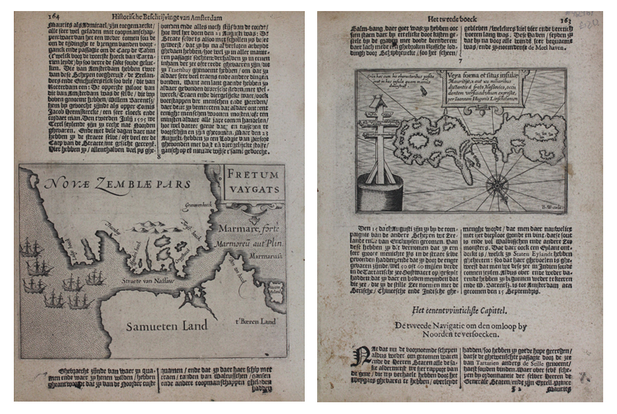
A miniature map of the Yugor Strait, here labelled the 'Nassau Strait,' the body of water separating the Russian island of Vaygach from the European mainland, from the 'Historische beschrijvinghe der seer wijt beroemde coop-stadt Amsterdam' by Pontanus. The island is labelled on the map as being part of Nova Zembla (Novaya Zemlya), while the mainland is called 'Samueten Land,' the Land of the Samoyeds. The first published survey of the region was that of Jan Huyghen van Linschoten, who sailed as part of the expedition of Willem Barentsz in 1594. The expedition's aim was the discovery of the Northeast Passage, and, despite making it through the straits and along the west coast of Nova Zembla, the icy conditions forced them to turn back. Their next expedition in 1595 got further, but upon reaching the frozen Kara Sea, the expedition realised that they could go no further. The ships featured on the west coast of Nova Zembla are likely intended to represent Barentsz' vessels. On the verso, a map engraved by Benjamin Wright depicts the Vera forma et situs insulae Mauritije, 'The true form and position of Maurice Island,' a small icy island to the west of the Nassau Straits. Jan Huyghen van Linschoten reported the discovery of a number of unusual crucifixes on the island, the form and location of which are demonstrated on the map. The island, as well as the nearby Orange Island were named after the ruling Stadtholder of the Dutch Republic at the time, Maurice of Nassau. 'Historische beschrijvinghe der seer wijt beroemde coop-stadt Amsterdam' (Historical description of the famous trading city Amsterdam) by Johannes Isaac Pontanus was first published in Latin ('Rerum et urbis Amstelodamensium historia') by Jodocus Hondius in Amsterdam in 1611. Three years later, in 1614, Jodocus Hondius had the book translated by Petrus Montanus into Middle-Dutch and published it again. The book was put on the Index because of its hostility towards Roman Catholics. The book was essentially a cumulative history of all Dutch knowledge of the world, through the efforts of the Dutch East Indies Company (VOC) and their various commercial and exploratory enterprises. This print is from a rare Dutch edition of the publication. Benjamin Wright (fl. 1596-1613) was an English cartographer and engraver, who spent much of his working life in Venice and Amsterdam. He is best known for his work engraving maps for Magini's atlas of Italy, Barent Langenes Caert Thresor, and Pontanus' history of Amsterdam. A number of letters written by Magini suggest Wright was not the easiest of colleagues, being prone to bouts of alcoholism, and on a number of occasions, was apparently responsible for pawning Magini's plates to other publishers in order to fund his libertine pursuits. Johannes Isacius Pontanus (1571–1639) was born when his parents had fled Haarlem to go to Denmark. He later adopted his academic name Pontanus ("of the sea") because he would have been born at sea, when his parents were still on their way to Denmark. Shortly after his birth, his father Isaach Pietersz. was appointed by the Danish King Frederik II to return to the Netherlands and work as an agent. The family settled in Amsterdam, were Pontanus would spent most of his childhood. He would go on to study in Utrecht and Leiden and was promoted to doctor of medicine in Basel in 1601. He traveled often to Denmark and also visited Germany, Italy and France. He became a professor at the Gymnasium Illustre in Gelderland in 1604 and was appointed as the Royal Danish historian by King Christian IV. He wrote a history of Amsterdam in 1611, of Denmark from 1618 to 1631 and of the States of Gelderland in 1639 as well as several shorter works of history. He was married to Anneken van Heede with whom he had nine children. Jodocus Hondius (14th October 1563 - 12th February 1612) was a Dutch Flemish cartographer, engraver, and publisher. Hondius is most famous for reviving the primacy of the work of Gerard Mercator, through the publication of his Atlas, and the smaller Atlas Minor, in the early seventeenth century, at a time when cartography was largely dominated by Ortelius' Theatrum Orbis Terrarum. The Mercator-Hondius Atlas was composed of maps pulled from plates Hondius had purchased from Mercator's grandson, as well as thirty-six new plates Hondius commissioned, and in many cases engraved, himself. He is also believed to have been the chief engraver of the plates for John Speed's Theatre of the Empire of Great Britaine. Following his death, he was succeeded by his sons, Jodocus the Younger and Henricus, as well as his son in law Jan Jansson. Condition: Strong, dark impressions on full sheet. Dutch text above and below plates. |
| Framing | unmounted |
| Price | £120.00 |
| Stock ID | 42961 |