
| Method | Copper engraved |
| Artist | van den Keere, Pieter |
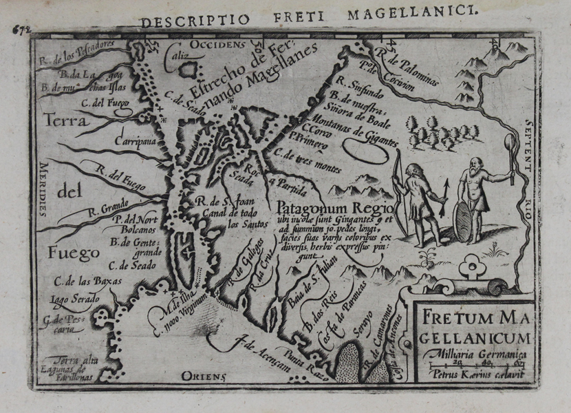
| Published | Petrus Kaerius caelavit [Cornelis Claesz et Jan Jansson, Amsterdam et Arnhem, 1602] |
| Dimensions | 88 x 125 mm |
| Notes |
A miniature map of the Straits of Magellan, the body of water dividing the Tierra del Fuego from the South American mainland, engraved by Keere for Barent Langenes' Caert-Thresoor. This example, featuring Latin verso text, as well as the addition of latitude marks along the top border, came from the 1602 printing of Bertius' Tabularum Geographicarum Contractarum. The map is shown with West to top, and a pair of Patagonian 'giants' are depicted above the title cartouche. Pieter van den Keere, also known frequently as Petrus Kaerius, came to England in 1584, as a Protestant refugee from his home town of Ghent with his sister Colette, who married Jodocus Hondius, in 1587. It was probably from Hondius that Keere learned to engrave. Both engravers left London in 1593 to settle in Amsterdam. His first set of miniature maps were produced for the Middelburg publisher Cornelis Claesz, for inclusion in Barent Langenes' Caert Thresoor. Keere began to engrave a series of miniature maps in 1599 in preparation for a small atlas of the British Isles. The maps were first published in 1617 by William Blaeu with plate numbers and Latin text. They then passed to George Humble, who published them in 1619 and then again in 1627, by which time they had become known colloquially as 'Miniature Speeds.' Barent Langenes (fl. 1597/1598) was a Dutch bookseller and publisher. Little is known about his life and work, apart from his publication of 'Caert-Thresoor' in Middelburg in 1598. The atlas was for sale at Cornelis Claesz's shop in Amsterdam, and was later republished by Claesz, without the Langenes name. The atlas was published by several publishers in different languages between 1598 and 1650 and became quite popular this way. Today the Langenes atlas is mostly associated with Petrius Bertius, who published the first Latin edition in 1600 under the title 'Tabularum Geographicarum Contractarum'. Petrus Bertius (14th November 1565 – 13th October 1629) was a Flemish theologian, historian, geographer and cartographer and was related to Jodocus Hondius Sr. and Pieter van den Keere by marriage. Bertius studied at the University of Leiden and later traveled in Germany and Russia. In 1620 he emigrated to France where he was appointed as a cosmographer to the court Louis XIII. Bertius published a number of folio maps, but never published an atlas of his own. His maps were either separately published or included in atlases and books by other publishers. Condition: Strong dark impression. Printers thumbprint in bottom left corner of map. Letterpress title misaligned with plate at top. Latin text on verso. |
| Framing | mounted |
| Price | £200.00 |
| Stock ID | 47424 |