
| Method | Copper engraved |
| Artist | Janson |
| Published | Amstelodami, Sumptibus Ioannis Ianssonii. [c. 1636] |
| Dimensions | 489 x 376 mm |
| Notes |
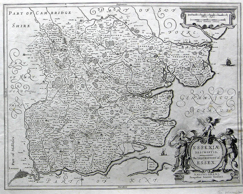
A large and decorative map of the county of Essex, from a German edition of Hondius and Jansson's Atlas. The map shows the whole county, divided into Hundreds, and outlined in early hand colour. Forests, rivers, and hills are shown pictorially, and cities, towns, and villages are extensively labelled. London, beyond the county's southwestern corner, is shown in individual detail, with London Bridge and Old St Paul's clearly visible. In the bottom right corner, a large baroque cartouche encloses the title in Latin and English, flanked by the gods Apollo and Pan, and surmounted by a putto. Another cartouche in the top right contains the scale in English and German miles. The map predates the more familiar impression which was included in Jansson's Atlas Novus from 1646 onwards, and does not yet contain the characteristic series of armorials in the top left corner, celebrating notable members of the Essex gentry. Henricus Hondius (1597 - 16th August 1651), often called Hendrik Hondius the Younger to differentiate him from the earlier, and unrelated portrait engraver Hendrik Hondius the Elder, was the son of the famous cartographer Jodocus Hondius. Like his father, Henricus was an engraver, cartographer, and publisher. He first came to prominence through his publication in 1606 of a new version of Mercator's 1569 World Map, the plates for which he had obtained from Mercator's grandson Rumold. Following his father's death, Henricus co-ran the family business, eventually partnering with his brother-in-law, Jan Jansson. Johannes Janssonius (1588 - 1664) was a famed cartographer and print publisher. More commonly known as Jan Jansson, he was born in Arnhem where his father, Jan Janszoon the Elder, was a bookseller and publisher. In 1612 he married the daughter of the cartographer and publisher Jodocus Hondius, and then set up in business in Amsterdam as a book publisher. In 1616 he published his first maps of France and Italy and from then onwards, produced a very large number of maps which went some way to rival those of the Blaeu family, who held a virtual monopoly over the industry. From about 1630 to 1638 he was in partnership with his brother-in-law, Henricus Hondius, issuing further editions of the Mercator/Hondius atlases to which his name was added. On the death of Hondius he took over the business, expanding the atlas still further, until eventually he published an eleven volume Atlas Major on a scale similar to Johannes Blaeu's magnum opus. After Jansson's death, his heirs published a number of maps in the Atlas Contractus of 1666, and, later still, many of the plates of his British maps were acquired by Pieter Schenk and Gerard Valck, who published them again in 1683 as separate maps. Condition: Central vertical fold, as issued. Light creasing to sheet, tears to margins and top of centre fold. Foxing to sheet and map. Surface abbrassion to top left of plate. |
| Framing | unmounted |
| Price | £400.00 |
| Stock ID | 4577 |