
| Method | Copper engraved with hand colour |
| Artist | Speed, John |
| Published | Described by John Norden. Augmented by I. Speede. And are to be solde by G. Humble. Cum privilegio. [1611-12] |
| Dimensions | 382 x 509 mm |
| Notes |
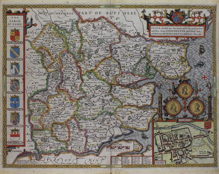
An early impression of John Speed's highly decorative map of the county of Essex. Featured in the lower right corner is a detailed plan of Colchester, with a lettered key set to the left. Above the plan are coin portraits of the Roman Emperor Constantine and his parents, which in turn reflects Colchester's Roman roots, and its status as the oldest settlement in the country. Adorning the left of the map are arms of the Earls of Essex. English text on verso describing the history and topography of the county, accompanied by a list of Essex's hundreds, and an alphabetical list of place names. John Speed (1552-1629) is the most famous of all English cartographers primarily as a result of The Theatre of the Empire of Great Britaine, the first atlas of the British Isles. The maps from this atlas are the best known and most sought-after of all county maps. The maps were derived mainly from the earlier prototypes of Christopher Saxton and John Norden but with notable improvements including parish "Hundreds" and county boundaries, town plans and embellishments such as the coats of arms of local Earls, Dukes, and the Royal Household. The maps are famed for their borders consisting of local inhabitants in national costume and panoramic vignette views of major cities and towns. An added feature is that regular atlas copies have English text printed on the reverse, giving a charming description of life in the early seventeenth century of the region. The overall effect produced very decorative, attractive and informative maps. For the publication of his prestigious atlas, Speed turned to the most successful London print-sellers of the day, John Sudbury and George Humble. William Camden introduced the leading Flemish engraver, Jodocus Hondius Sr. to John Speed in 1607 because first choice engraver William Rogers had died a few years earlier. Work commenced with the printed proofs being sent back and forth between London and Amsterdam for correction and was finally sent to London in 1611 for publication. The work was an immediate success, with the maps themselves being printed for the next 150 years. Speed was born in 1552 at Farndon, Cheshire. Like his father before him he was a tailor by trade, but around 1582 he moved to London. During his spare time Speed pursued his interests of history and cartography and in 1595 his first map of Canaan was published in the "Biblical Times". This raised his profile and he soon came to the attention of poet and dramatist Sir Fulke Greville a prominent figure in the court of Queen Elizabeth. Greville as Treasurer of the Royal Navy gave Speed an appointment in the Customs Service giving him a steady income and time to pursue cartography. Through his work he became a member of such learned societies as the Society of Antiquaries and associated with the likes of William Camden, Robert Cotton, and William Lambarde. He died in 1629 at the age of seventy-seven. Condition: Pressed centre fold, as issued. Repair to top and bottom of fold. Paper wear to lower left margin. Minor areas of foxing. |
| Framing | unmounted |
| Price | £1,000.00 |
| Stock ID | 45859 |