
| Method | Copper engraved |
| Artist | Godin, Henri-Joseph |
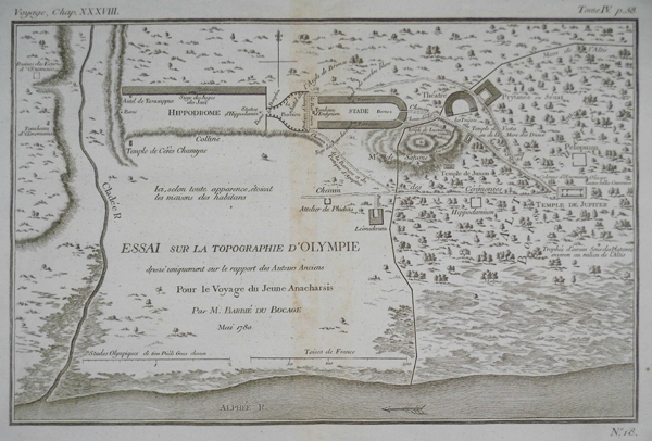
| Published | Par M. Barbié du Bocage. Mai 1780. |
| Dimensions | 184 x 287 mm |
| Notes |
A plan of the Greek city of Olympia, Plate 18 from the 1788 edition of Barbie du Bocage's Recueil de Cartes Geographiques Plans, Vues, et Medailles de l'Ancienne Grece, Reelatifs au Voyage du Jeune Anacharsis. The city of Olympia is shown with particular reference to religious and sporting edifices. The plan is bordered at the bottom and left by the rivers Alphaeus and Cladeus. The most recognisable monuments are the Hippodrome and the Stadium, though the Theatre, Prytaneion (meeting-house), and the Temple of Zeus are also prominently featured. Smaller sanctuaries, temples, and unusual buildings like the workshop of Pheidias and the tomb of the hero Oenomaus are illustrated with explanatory titles. The city of Olympia grew to fame largely due to the fact that it was host to the Olympic Games, the oldest and most important of the four Panhellenic sporting festivals. The Olympics were purported to have first been held in 776 BC and were celebrated almost continuously every four years until the Roman emperor Theodosius passed an edict in AD 394 abolishing pagan festivals and closing sanctuaries and temples across the Roman world. In addition to its sporting role, Olympia was also an important religious sanctuary. The oldest buildings on the site suggest it was originally a cult sanctuary to the goddess Hera, though by the classical period, this had been eclipsed by worship of Zeus, king of the gods and husband of Hera. The Temple of Olympian Zeus, completed by the mid 5th-century BC, was considered the perfect example of a Classical temple in the Doric Order. By the Hellenistic period, the temple's fame warranted its inclusion as one of the Seven Ancient Wonders. Its most famous attribute was the cult statue of Zeus, created by the master sculptor Pheidias of chryselephantine, ivory and gold laid over a wooden frame. The statue became a symbol for Olympia as a whole, appearing on the city's coinage. The fate of the statue is unknown. One narrative records its transferral at the behest of Constantine to Constantinople, along with many other famous works of ancient art, where it was probably destroyed in the fire at the Palace of Lausus. Otherwise, it likely perished when the Temple at Olympia burned down in AD 425. The Recueil de Cartes Geographiques Plans, Vues, et Medailles de l'Ancienne Grece, Reelatifs au Voyage du Jeune Anacharsis was an atlas published by the Paris booksellers, printmakers, and engravers Jean Denis Barbie du Bocage to accompany Jean-Jacques Barthelemy's Voyage du jeune Anacharsis en Grèce dans le milieu du IVe siècle. The Voyage du jeune Anacharsis was an unusual work. Written as a sort of general guidebook to the cities, customs, and culture of classical Greece, it purported to be the work of the grandson of the Scythian philosopher Anacharsis, documenting his travels in Greece during the 4th century BC. This clever literary conceit allowed the real author, Barthelemy, to explore the history and society of Classical Greece in a manner that was informative, yet informal, aiming to appeal to a much broader audience than a traditional academic history. Barthelemy was a talented antiquarian, particularly in regards to the study of ancient numismatics, and although the content of his work contains numerous historical flaws, the Voyage du jeune Anacharsis was a huge success, appearing in numerous editions and reprints. Sadly Barthelemy received very little from his success, his aristocratic background marking him as a target for the Revolutionary government, who confiscated most of his wealth. Despite his economic hardships, the general public continued to hold him in high esteem, and the demand for his material on ancient Greece was the main motivation behind the publication in 1788 of the accompanying Atlas to the Voyage. The first edition of Barbie's Recueil contained 31 plates related to Barthelemy's text, including maps of cities and territories, plans of battles, religious sanctuaries, and public spaces, and illustrations of temples, theatres, and even coins. Henri-Joseph Godin (1747-1834) was a French painter, engraver, and printmaker. He worked on maps for a number of atlases, as well as portraits, architectural plans, and antiquarian subjects. Condition: Central vertical fold as issued. Minor adhesive discolouration to central fold. Small brown ink-spot to right edge of plate, not affecting image. |
| Framing | unmounted |
| Price | £40.00 |
| Stock ID | 13261 |