
| Method | Etching with hand colouring |
| Artist | Heinrich Keller |
| Published | [Zürich, Fussli Komm., c. 1813] |
| Dimensions | Images approx. 85 x 550 mm, Sheet 375 x 572 mm |
| Notes |
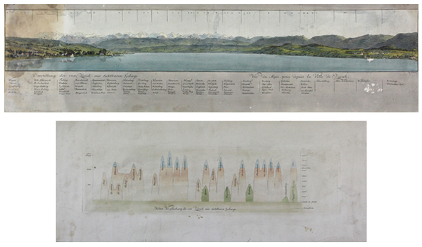
Panoramic view of the Alps from the Swiss city of Zürich with a key to the different mountains, hills and regions. Manuscript additions made to the key. Laid the same album page is a graph showing the altitudes of the different mountains and hills. Heinrich Keller (1778-1862) was a Swiss draughtsman and cartographer who mainly produced maps and topographical panorama's. He lived and worked in Zürich , but also travelled through Switzerland to produce the first traveller's map of Switzerland in 1813 'Reisekarte der Schweiz'. He worked together with Johann Kaspar Zellweger (1768–1855) to produce 'Zollkarte der Schweiz' (Customs map of Switzerland) in 1825, made several hiking maps in the 1830's and often worked together with the Zürich publishing company Füssli & Cie. Condition: Two prints on separate sheets of paper, laid to an album page. The panoramic view of the Alps: trimmed to the margins on the sides, surface abrasions to sheet. The graph with the altitudes of the Alps: light toning and dirt build-up to sheet, wide margins. Both sheets and the backing paper have overall discolouration, several small stains, tears and water damage to left hand side. |
| Framing | unmounted |
| Price | £150.00 |
| Stock ID | 43802 |