
| Method | Lithograph with original hand colour |
| Artist | Weller, Edward |
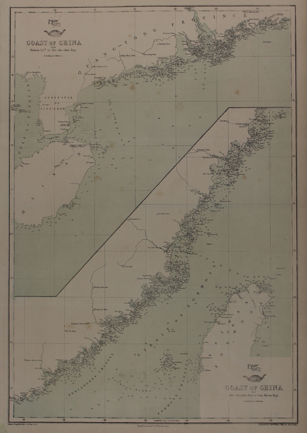
| Published | Weekly Dispatch Atlas, 139 Fleet Street. Day & Son Lithrs. to The Queen. Engraved by Edwd. Weller Duke Str. Bloomsbury [London, 1863] |
| Dimensions | 435 x 305 mm |
| Notes |
A pair of lithographed maps on the same plate, showing the coastlines of China, from The Weekly Dispatch Atlas. The map covers China's southern coast, split across the two maps. At top is Hainan Island and the Qiongzhou Straits, moving northeast along the coast of Guangdong Province, including Canton (modern Guangzhou), Macao, and Hong Kong. The lower map continues up the coast, with the remaining coastline of Guangdong province, as well as Fujian and Zhejiang provinces. Most of the island of Taiwan/Formosa is also shown. Between 1857 and 1863, the British newspaper The Weekly Dispatch published a series of maps. Over 100 maps were produced, and in 1863, the maps were gathered together to form The Dispatch Atlas. The atlas contained county and country maps, as well as several city maps. Each of the maps featured a distinctive image of a half-globe with a winged mercury above. Edward Weller, FRGS (d.1884) was an engraver, publisher and cartographer. He had premises in London at 34, Red Lion Square (1861) and Duke Street, Bloomsbury (1872). He often worked for George Philip and Son, and William Collins, Sons, & Co. Many of his maps were included in student atlases. Weller's business was continued by his wife Mary Anne (d.1887) and his son Francis Sidney (d.1910). Condition: Vertical and horizontal folds. Minor time toning to edges of sheet. Small chip to top left corner, not affecting map. Partial Weekly Dispatch blindstamp on bottom left corner of sheet. Blank on verso. |
| Framing | unmounted |
| Price | £95.00 |
| Stock ID | 48706 |