| Method | Chromolithograph |
| Artist | [Anonymous] |
| Published | Copyright: Entered at Stationers' Hall. By the Author of 'The Map of Truelove River' Postcard. Knight Series [c.1905] |
| Dimensions | 87 x 138 mm |
| Notes |
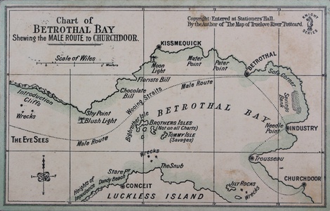
A novelty cartographic Edwardian postcard, one of the popular 'Knight Series' of romantic allegories, this one showing a mock sea-chart of 'Betrothal Bay' with the Male Route from courtship to marriage plotted as a dotted line. The route begins at 'The Eye Sees (Seas),' avoiding the wrecks at Introduction cliffs. After wooing his intended with chocolates, flowers, and a moonlight stroll, the first major settlement on the coast is 'Kissmequick.' The headlands of her parents lead to the town of Betrothal, and from there a journey along the coast via Savings Bank and Needle Point near the town of Industry takes the male to Trousseau and his final goal of Churchdoor. In the middle of the Bay are the Brothers Isles, which are sometimes uncharted, a land of savages called Tommy Isle, and at the bottom of the map, a region to be avoided called 'Luckless Isle' and its topographical pitfalls including Jilt Rocks, The Snub, the town of Conceit nearby Dandy Beach, and the Heights of Impudence. The postcard is used, and on the verso features a short note of well wishing to a Miss A Lummers, Whitfield nr. Brackley, Northants, as well as an Edward VII half-penny stamp. The stationer Knight Brothers describes the series as 'The Sentimental Novelty Post Card.' Condition: Minor wear and creasing to edges of card. Patches of minor dirt and ink staining. |
| Framing | mounted |
| Price | £50.00 |
| Stock ID | 50731 |

