
| Method | Copper engraved with hand colour |
| Artist | Chatelain, Henri Abraham |
| Published | Avec Privilege de Nosseigneurs les Etats de Hollande et de West-frize [Amsterdam, c.1719] |
| Dimensions | 515 x 600 mm |
| Notes |
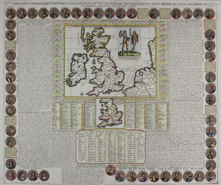
A detailed and beautiful chart of English history, featuring a pair of maps of England and Wales, from Chatelain's Atlas Historique. The larger of the two maps shows the British Isles at the time of the Roman invasion, with the pre-Roman Celtic tribes and their territories marked, along with their fellow tribes on the European mainland. Roman settlements and cities are picked out in red and labelled with their latin titles in cursive. A large illustration in the top right shows the ahistoric, but charming, national dress of the naked and tattooed ancient Britons. Dashed and dotted lines also mark the migratory invasions of the Saxons and Danes. Below, a smaller boxed map divides England and Wales into the kingdoms of the Anglo-Saxon heptarchy. The decorative border features roundels representing the monarchic line of the Kingdom of England, from Egbert to Queen Anne, while the line of Roman Emperors encircle the maps at centre. The rest of the sheet is taken up by large boxes of explanatory text. Full title: Carte pour l'Introduction a l'Histoire d'Angleterre ou l'on voit son premier gouvernement, et l'Etat abrege de cette Monarchie sous les Empereurs Romains, et sous les Rois Saxons. Henri Abraham Chatelain (1684-1743) was a Dutch cartographer of Parisian origins, who lived and worked in St. Martins, London (c. 1710), The Hague (c. 1721), and Amsterdam (c. 1728). He is best known for the seminal seven volume Atlas Historique (published in Amsterdam, 1705 - 20) which combined maps and topography with scholarly studies of geography, history, ethnology, heraldry, and cosmography. The Atlas was a family undertaking, managed by Henri and his father, Zacharie, and going through a number of editions. The majority of the maps for the work were engraved by Henri after charts by De L'Isle. Condition: Vertical and horizontal folds as issued. Minor staining and repaired tears to edges of sheet, not affecting map. Small thinned hole to top left margin. Blank on verso. |
| Framing | unmounted |
| Price | £300.00 |
| Stock ID | 48482 |