
| Method | Copper engraved with hand colour |
| Artist | Chatelain, Henri Abraham |
| Published | Paris, 1710. |
| Dimensions | 362 x 426 mm |
| Notes |
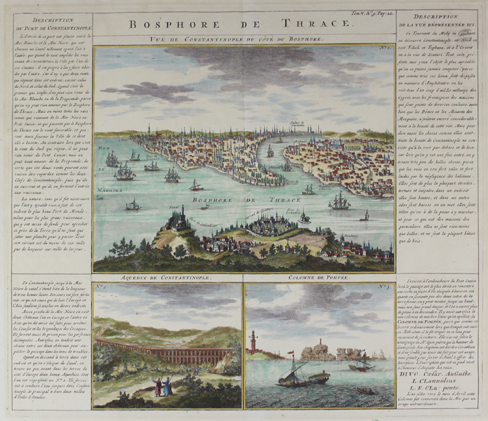
A sheet from Chatelain's Atlas Historique dominated by a beautifully engraved and coloured aerial view of Constantinople with views of the aqueduct and Pompee Column below and columns of text either side describing Constantinople and the two other views depicted. Henri Abraham Chatelain (1684-1743) was a Dutch cartographer of Parisian origins, who lived and worked in St. Martins, London (c. 1710), The Hague (c. 1721), and Amsterdam (c. 1728). He is best known for the seminal seven volume Atlas Historique (published in Amsterdam, 1705 - 20) which combined maps and topography with scholarly studies of geography, history, ethnology, heraldry, and cosmography. The Atlas was a family undertaking, managed by Henri and his father, Zacharie, and going through a number of editions. The majority of the maps for the work were engraved by Henri after charts by De L'Isle. Condition: Centrefold as issued, sort tear 10mm tear into fold at the bottom not affecting the image or plate. Some light time toning from a previous mount. |
| Framing | unmounted |
| Price | £350.00 |
| Stock ID | 49008 |