
| Method | Copper engraved with hand colour |
| Artist | Blaeu, Johannes |
| Published | c.1654 |
| Dimensions | 412 x 528 mm |
| Notes |
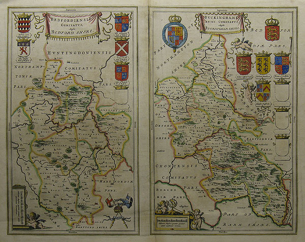
Blaeu, Doctor Johannes (c.1599-1673) Born and died in Amsterdam. He collaborated with his father Willem Janszoon and with his brother Cornelis, and ran the business after the death of Willem. Johannes was appointed official cartographer to the East India Company (VOC) in 1638 in sucession to his father. What was left of the company after the fire of 1672 and the death of Joan in 1673 passed to his son Joan (III), who sold the globemaking part of the business to J. van Keulen. Johannes worked in partnership with his father on Theatri Ortelii et Atlantis G. Mercatoris, 1631 and Nouvus Atlas, 1634; Wall maps, 1647-1649; Tooneel der Steden van der Vereenighde Nederlanden (Town books of the Netherlands) 1649-1653 Theatrum Orbis Terrarum, publishing six volumes up to 1655; Atlas Major (11 volumes, known as the Grand Atlas), 1662-1672 in editions with French, Latin, Dutch and Spanish text (often described as the most magnificent work of its kind ever produced); Town plans of Italy 1663. This dual map of Bedfordshire and Buckinghamshire contains the usual Blaeu decorations; including the royal coat of arms together with those of the noble families of the county and scenes of local life. A description of the counties also appears verso in Latin. Condition: Large repaired vertical split to the top of the centre fold; impacts upon the platemark of the Buckinghamshire image. Vertical crease as issued. |
| Framing | unmounted |
| Price | £300.00 |
| Stock ID | 27275 |