| Method | Copper engraved with hand colour |
| Artist | Visscher, Nicolas |
| Published | [Amsterdam, c. 1680] |
| Dimensions | 433 x 540 mm |
| Notes |
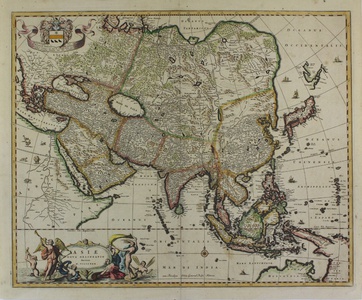
A highly decorative map of Asia and the East Indies, published by Nicolaes Visscher in Amsterdam and later in Jan Jansson atlases. The map shows Korea as a peninsula. The delineation of Japan follows that of the Mercator-Hondius, with addition of De Vries' discoveries in Yesdo. In China the Great Wall is depicted, as well as a long stretch of desert, identified as the Xamo. Australia and New Guinea include new discoveries of Tasman, Janszoon and Cartensz. Beautiful detailing throughout with rivers, mountains and forests, as well as sailing vessels and a compass rose. Several animals are shown on the African continent such as an ostrich, elephant and rhinoceros. The title is enclosed in a decorative cartouche on the lower left, and a cartouche with dedication to Henrico Spieghel, the Senator of Amsterdam, as well as his coat of arms, are shown at the top left. The Visscher family produced maps and atlases in Amsterdam throughout the seventeenth and early eighteenth century. Established by Claes Janszoon Visscher (1587-1652), they mainly published atlases from plates purchased from Pieter van den Keere. The business was then continued by Claes' son Nicolas Visscher I (1618-1679) and his grandson Nicolas II. The Visschers published many revised editions of their 'Atlas Contractus' and 'Atlas Minor'. Upon the death of Nicholas II, his wife, Elizabeth, continued the business before selling it to Pieter Schenk. Johannes Janssonius (1588 - 1664) was a famed cartographer and print publisher. More commonly known as Jan Jansson, he was born in Arnhem where his father, Jan Janszoon the Elder, was a bookseller and publisher. In 1612 he married the daughter of the cartographer and publisher Jodocus Hondius, and then set up in business in Amsterdam as a book publisher. In 1616 he published his first maps of France and Italy and from then onwards, produced a very large number of maps which went some way to rival those of the Blaeu family, who held a virtual monopoly over the industry. From about 1630 to 1638 he was in partnership with his brother-in-law, Henricus Hondius, issuing further editions of the Mercator/Hondius atlases to which his name was added. On the death of Hondius he took over the business, expanding the atlas still further, until eventually he published an eleven volume Atlas Major on a scale similar to Johannes Blaeu's magnum opus. After Jansson's death, his heirs published a number of maps in the Atlas Contractus of 1666, and, later still, many of the plates of his British maps were acquired by Pieter Schenk and Gerard Valck, who published them again in 1683 as separate maps. Condition: Excellent impression. Pressed vertical centre fold as issued. Occasional very light foxing. |
| Framing | unmounted |
| Price | £875.00 |
| Stock ID | 43294 |

