
| Method | Copper engraved |
| Artist | Quad, Matthias and Bussemacher, Johann |
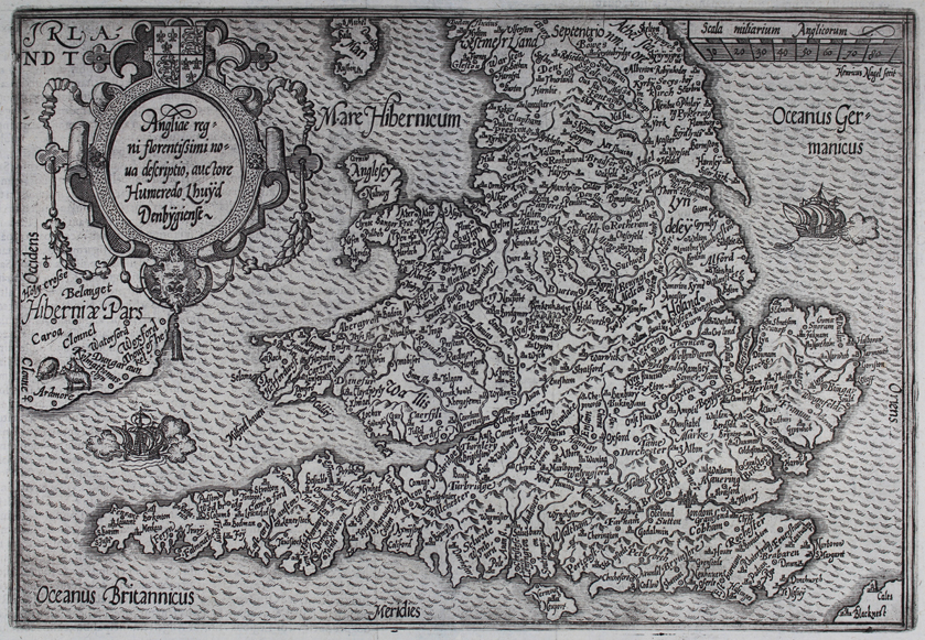
| Published | Henricus Nagel fecit [Cologne, c.1605] |
| Dimensions | 182 x 265 mm |
| Notes |
An attractive quarto map of the British Isles, engraved by Henricus Nagel for Quad's Europae totius orbis terrarum partis praestantissimae, universalis, et particularis descriptio. Cartographically, the map is a relatively close copy of the Ortelius map of the British Isles, itself based on the survey of the Welsh geographer, Humphrey Llwyd. Quad's map first appeared in his European atlas of 1592, and was reprinted in Cologne five times between 1593 and 1608. It also appeared, unchanged, in geographical works published by Johannes Rauw in Frankfurt. This particular example is outlined in beautiful hand colour, and cities, mountain ranges, and forests are also picked out in hand colour. The map is very heavily annotated with place names in Quad's distinctive and attractive italic text, and the seas are marked with fine wavy patterns. A pair of ships are also included, one off the north Cornish coast, the other east of Yorkshire. The eastern and southern coasts of Ireland are included, as well as the port of Calais. The map is further enhanced by a large decorative strapwork title cartouche at top left, and a scale in British miles at top right. Matthias Quad (1557-1613) was a Dutch-German cartographer, geographer, author, engraver, and publisher. Born in the Netherlands, Quad was one of a number of leading lights in the mapmaking community of Cologne at the turn of the sixteenth and seventeenth centuries. Aside from working as an engraver for Braun and Hogenberg's Civitates Orbis Terrarum, Quad also partnered with Johann Bussemacher in the production of a number of smaller scale atlases, inspired by the success of Ortelius' Theatrum Orbis Terrarum. The first, an atlas of Europe, was published in 1592. This was later expanded into the Geographisch Handtbuch of 1600, and finally the Fasciculus Geographicus in 1608. Johann Bussemacher (fl.1580-1613) was a German publisher, printer, art dealer, and engraver, active in Cologne at the turn of the sixteenth and seventeenth century. His is best remembered for a series of engravings of the Labours of Hercules after Aldegrever, and for preparing many of the map plates for three atlases he co-published with Matthias Quad. Shirley 172 Condition: Strong impression with full margins. Central vertical fold as issued, light stain to bottom left. Latin text on verso. |
| Framing | mounted |
| Price | £475.00 |
| Stock ID | 50021 |