
| Method | Copper engraved with hand colour |
| Artist | Mercator, Gerard and Hondius, Jodocus |
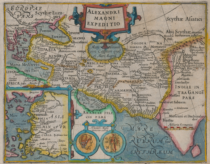
| Published | [Amsterdam, c.1620] |
| Dimensions | 150 x 190 mm |
| Notes |
A decorative miniature map of the Middle East depicting the conquests of Alexander the Great, King of Macedon, from a Latin edition of the Mercator-Hondius Atlas Minor. The map depicts the ancient kingdoms and regions of Greece, Asia Minor, Libya, Egypt, Arabia, Mesopotamia, Bactria and Sogdiana, Parthia, Arachosia, Gadrosia, and the Valley of the Indus River, outlined in hand colour. Principal cities are picked out in red, and the map is heavily annotated with references from the classical source tradition for Alexander's expeditions. The terminus of Alexander's expedition, on the banks of the Indus, is marked by a pair of altars near the source of the Ganges. The map is further embellished by a pair of strap-work cartouches. One encloses the title, while the larger of the two in the bottom left corner shows an inset map of the Aegean Sea and the coast of Asia Minor. At bottom centre, an Alexandrian coin shows the Conquerors helmeted head on the recto and a winged Nike holding an orb and sceptre on the verso. The map was likely inspired by a similar large scale example published by Ortelius for the Parergon, a collection of maps on classical and biblical subjects intended as a supplement to the famous Theatrum Orbis Terrarum. Gerard Mercator (1512 - 1594) originally a student of philosophy was one of the most renowned cosmographers and geographers of the 16th century, as well as an accomplished scientific instrument maker. He is most famous for introducing Mercators Projection, a system which allowed navigators to plot the same constant compass bearing on a flat map. His first maps were published in 1537 (Palestine), and 1538 (a map of the world), although his main occupation at this time was globe-making. He later moved to Duisburg, in Germany, where he produced his outstanding wall maps of Europe and of Britain. In 1569 he published his masterpiece, the twenty-one-sheet map of the world, constructed on Mercator's projection. His Atlas, sive Cosmographicae Meditationes de Fabrica Mundi, was completed by his son Rumold and published in 1595. After Rumold's death in 1599, the plates for the atlas were published by Gerard Jr. Following his death in 1604, the printing stock was bought at auction by Jodocus Hondius, and re-issued well into the seventeenth century. Jodocus Hondius (14th October 1563 - 12th February 1612) was a Dutch Flemish cartographer, engraver, and publisher. Hondius is most famous for reviving the primacy of the work of Gerard Mercator, through the publication of his Atlas, and the smaller Atlas Minor, in the early seventeenth century, at a time when cartography was largely dominated by Ortelius' Theatrum Orbis Terrarum. The Mercator-Hondius Atlas was composed of maps pulled from plates Hondius had purchased from Mercator's grandson, as well as thirty-six new plates Hondius commissioned, and in many cases engraved, himself. He is also believed to have been the chief engraver of the plates for John Speed's Theatre of the Empire of Great Britaine. Following his death, he was succeeded by his sons, Jodocus the Younger and Henricus, as well as his son in law Jan Jansson. Condition: Trimmed to platemark at bottom right, without loss to map. Latin letterpress title above, and Latin letterpress text on verso. |
| Framing | framed |
| Price | £500.00 |
| Stock ID | 52486 |