
| Method | Copper engraved with original hand colour |
| Artist | Boulton, Samuel |
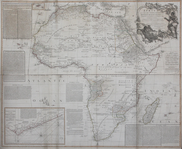
| Published | By S. Boulton. London. Published by Laurie & Whittle, No. 53, Fleet Street, as the Act directs, 12th May 1794 |
| Dimensions | 1040 x 1220 mm |
| Notes |
One of the most celebrated and important eighteenth century maps of Africa, based upon the d'Anville map and printed over four sheets by Laurie & Whittle for Kitchin's General Atlas, describing the Whole Universe: being a complete collection of the most approved maps extant; corrected with the greatest care, and augmented from the last edition of D'Anville and Robert with many improvements by other eminent geographers. The map, an impressive and very large wall map of the entire continent, was originally printed by Robert Sayer in the previous decade, becoming a watershed for the mapping of Africa. This particular example is the Laurie & Whittle printing of 1794. Unlike almost all previous maps of Africa, Boulton follows the example of d'Anville in excluding spurious, sensational, or apocryphal information. The result is that much of the interior of Africa, unexplored by Europeans, is here largely blank. The map was a huge undertaking, attempting to collect together all previous scientific knowledge of the continent, from the classical period to Boulton's present day. The map is covered with notes of cartographic, geological, exploratory, and ethnographic interest, and in the spaces on either side of the continent, commentaries discuss the different customs and habits of the various peoples of Africa. Although Boulton's encyclopaedic approach is commendable, the map is not necessarily the most up to date in its information, placing the commentaries of Pliny and Ptolemy, by this point over 15 centuries out of date, on an equal footing with the accounts of various European exploratory missions from his own century. Regardless, the map is fascinating in its detail. Each kingdom, state, and tribal area carries descriptions of its religion, history, conflict, or customs. The city of Timbuktu is mapped out in the interior of modern day Mali, the various communities of Jews, Christians, and Muslims in the Magreb are described, and the source of the Nile, as best known, is still shown as originating in a pair of lakes in the 'Lunar mountains.' In the south, a sailing ship rounds the Cape of Good Hope, and a lengthy discussion of Hottentot women segues into a table outlining the distribution of wealth from the region amongst the various officers of the Dutch Company. In the bottom left corner, a boxed inset map of the Gold Coast provides more information about the continent's wealth and interest to the colonial powers, while at the top left, a tiny inset map shows details of the Azores, the traditional dividing line between the holdings of the Portuguese and Spanish trading empires. The map is outlined in original hand colour, and at the top right features a large baroque title cartouche. The figures in the scene, sitting before a fire on which roasts a human leg, are possible the Jagas, prominently described on the map as 'Man Eaters.' Full title reads: Africa with all its States, Kingdoms, Republics, Regions, Islands, &c. Improved and Enlarged from D'Anville's Map to which have been added a Particular Chart of the Gold Coast wherein are Distinguished all the European Forts and Factories, and also A Summary Description relative to the Trade and Natural Produce, Manners and Customs of the African Continent and Islands Samuel Boulton (fl.1780-1800) was a British cartographer and geographer, known principally for his wall map of Africa, based upon d'Anville and originally published by Robert Sayer, and revised and reprinted a number of times by Sayer's successors Laurie & Whittle. Jean Baptiste Bourguignon d'Anville (11th July 1697 - 28th January 1782) was a French cartographer, geographer, and antiquarian, whose rigourous standards of geographic reference revolutionised map making during the latter half of the eighteenth century. Rather than rely on the authority of earlier cartographers in the creation of his maps, d'Anville insisted on verifiable evidence. The resulting maps looked vastly different from the work of his predecessors. Ornamentation was stripped back, and dubious locations were simply left blank. In 1754 he became a member of the Académie des Inscriptions et Belles Lettres, and in 1775 was appointed first geographer to King Louis XVI. Robert Laurie (c.1755-1836) was a British engraver, mezzotint artist, and publisher. In 1776, he was awarded a prize by the Society of Arts for the invention of a method of producing colour-printed mezzotints. Laurie succeeded the publisher Robert Sayer after the latter's death in 1794, and, in partnership with James Whittle, continued Sayer's prolific and well-established business on the Fleet Street, issuing prints, maps, illustrated books, charts, and nautical works. Following Laurie's retirement in 1812, Whittle continued in business with his former partner's son, Richard Holmes Laurie, who gained sole ownership of the business in 1818 with the death of Whittle. Condition: Printed over four sheets, folded and joined as issued. Original outline colour. Minor tears to folds. Minor time toning to edges of sheet, not affecting map. |
| Framing | unmounted |
| Price | £2,000.00 |
| Stock ID | 43628 |