
| Method | Copper engraved with original hand colour |
| Artist | Homann, Johann Baptist |
| Published | Edirt von Ioh. Baptist. Homann, Der Röm: Kays: Maj: Geographo, Cum Privilegio (in Nürg.) Sac. Caes. Maj. [Nuremberg, c.1720] |
| Dimensions | 485 x 575 mm |
| Notes |
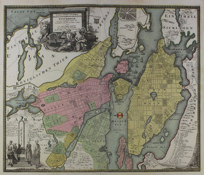
A superb early eighteenth century map of Stockholm, in full original hand colour, from the Maior Atlas Superiore. The map shows the city as it would have been during the Great Northern War, at the end of a period of prosperous growth. Following the conclusion of the war, which resulted in the partitioning of much of the Swedish Empire, the city entered a period of decline, though this has been seen by posterity as the beginning of the so-called Swedish 'Age of Liberty.' The different districts are coloured in a triple pastel palette of pink, green, and yellow, and numerous vessels are shown at anchor in Stockholm harbour. The map features 28 alphanumeric points of interest, corresponding to a key in the bottom right corner. In the bottom left corner, the scale is shown on a mile post, as part of a vignette illustrating Swedish national costume. The title, at top left, is enclosed in a a large vignette featuring an emblematic figure in classical dress and a lion. Johann Baptist Homann (20th March 1664 - 1st July 1724) was a German engraver and cartographer, and the Imperial Geographer to the Holy Roman Emperor Charles VI. In 1702 he opened a publishing house in Nuremberg, and his maps often make reference to his membership of the Prussian Royal Academy of Sciences and his imperial patronage. Upon his death, his maps passed to the Homann Heirs company and reprinted many times before the company closed in 1848. Condition: Central vertical fold, as issued. Minor time toning to sheet, otherwise a strong dark impression in full original colour. Blank on verso. |
| Framing | unmounted |
| Price | £850.00 |
| Stock ID | 47352 |