
| Method | Copper engraved with hand colour |
| Artist | Speed, John |
| Published | Are to be sold by Tho. Bassett in Fleet Street and Ric. Chiswell in St. Pauls Church yard. [London, 1676] |
| Dimensions | 395 x 518 mm |
| Notes |
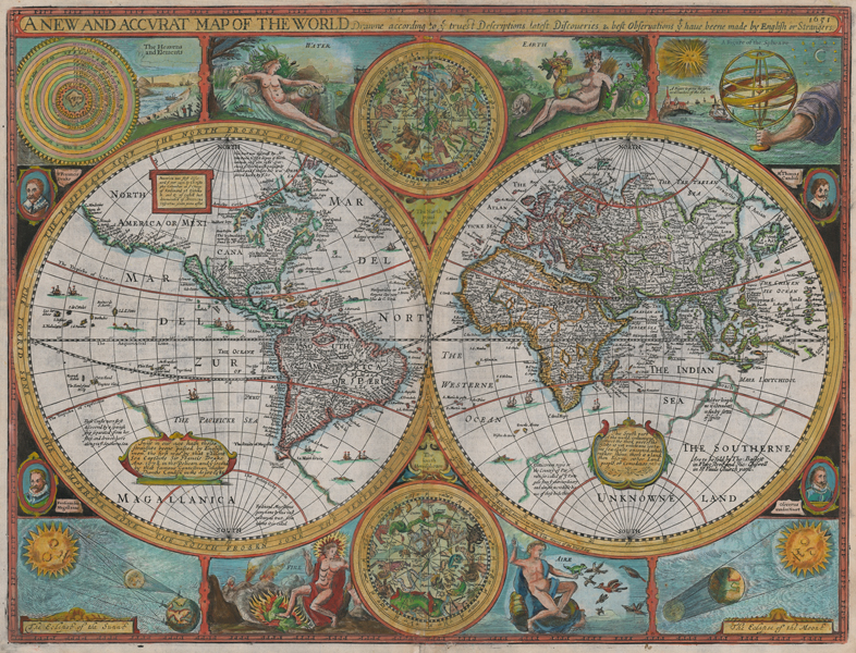
John Speed's double hemisphere map of the world, from the 1676 Bassett and Chiswell edition of the 'Prospect of the Most Famous Parts of the World.' The globe, divided into the New and Old worlds, is outlined in beautiful hand colour and features numerous notations in English about the exploration of the globe, and the extent of English cartographic knowledge at the beginning of the seventeenth century. Quirks include the 'Kingdom of Parrats,' the Land of Beach, and the spice-rich Maletur, all part of the massive southern super-continent of Magellanica. Japan is shown in as a squat oval, oriented at right angles to a truncated China. The phantom islands of Brazil and Frisland can be seen in the north Atlantic, and sea monsters and ships occupy many blank spaces in the oceans. Perhaps the most famous quirk of this map is the representation of California as an island, following William Grent's 1625 world map, though shown much more elongated than Grent's squat representation. In the spaces around the hemispheres, the map is crammed with decorative and scientific illustrations in a somewhat cruder style than the map itself, which was likely engraved by Abraham Goos. Like the earlier Hondius world map, the four elements are shown personified, flanking a pair of celestial hemispheres. The remaining spaces contain a Ptolemaic earth-centric model of the Solar System, a figure of an armillary sphere, and a pair of representations of the workings of solar and lunar eclipses. Four small portraits celebrate the contribution of Englishmen and 'Strangers' to cartographic and geographic knowledge, showing Sir Francis Drake, Thomas Cavendish (here rendered as 'Candish'), Ferdinand Magellan, and Oliver van Noort. John Speed (1552-1629) is the most famous of all English cartographers primarily as a result of The Theatre of the Empire of Great Britaine, the first atlas of the British Isles. The maps from this atlas are the best known and most sought-after of all county maps. The maps were derived mainly from the earlier prototypes of Christopher Saxton and John Norden but with notable improvements including parish "Hundreds" and county boundaries, town plans and embellishments such as the coats of arms of local Earls, Dukes, and the Royal Household. The maps are famed for their borders consisting of local inhabitants in national costume and panoramic vignette views of major cities and towns. An added feature is that regular atlas copies have English text printed on the reverse, giving a charming description of life in the early seventeenth century of the region. The overall effect produced very decorative, attractive and informative maps. For the publication of his prestigious atlas, Speed turned to the most successful London print-sellers of the day, John Sudbury and George Humble. William Camden introduced the leading Flemish engraver, Jodocus Hondius Sr. to John Speed in 1607 because first choice engraver William Rogers had died a few years earlier. Work commenced with the printed proofs being sent back and forth between London and Amsterdam for correction and was finally sent to London in 1611 for publication. The work was an immediate success, with the maps themselves being printed for the next 150 years. Speed was born in 1552 at Farndon, Cheshire. Like his father before him he was a tailor by trade, but around 1582 he moved to London. During his spare time Speed pursued his interests of history and cartography and in 1595 his first map of Canaan was published in the "Biblical Times". This raised his profile and he soon came to the attention of poet and dramatist Sir Fulke Greville a prominent figure in the court of Queen Elizabeth. Greville as Treasurer of the Royal Navy gave Speed an appointment in the Customs Service giving him a steady income and time to pursue cartography. Through his work he became a member of such learned societies as the Society of Antiquaries and associated with the likes of William Camden, Robert Cotton, and William Lambarde. He died in 1629 at the age of seventy-seven. Shirley 317 iv/iv. Condition: Central vertical fold as issued. Minor time toning to edges of sheet, and to central fold. Repaired tears to central fold. English text on verso. |
| Framing | framed |
| Price | £12,000.00 |
| Stock ID | 51947 |