
| Method | Copper engraved |
| Artist | [Jefferys, Thomas] |
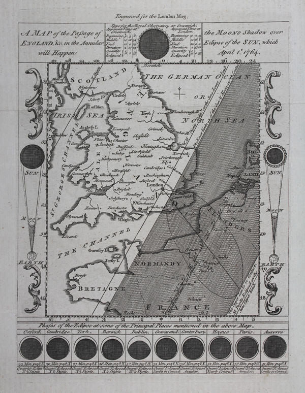
| Published | Engraved for the London Mag. [London, 1764] |
| Dimensions | 210 x 160 mm |
| Notes |
A map of the path and phases of the solar eclipse of 1764, engraved for The Gentleman's Magazine: and Historical Chronicle, most likely by Thomas Jefferys. The shadow of the eclipse passed over the southeastern coast of England, the Channel, and the western coasts of Holland, Belgium, and Normandy. The path of the eclipse is marked by a shaded patch on the map, with the greatest extent visible from London marked as a dotted oval. The map is surrounded by a large decorative border, which features vignettes and information about the eclipse. At top centre, a diagram of the eclipse's appearance from the Greenwich Observatory is shown, along with times and details of its progress. Along the bottom of the map, the eclipse is shown as it will appear at its greatest extent if viewed from Oxford, Cambridge, York, Berwick, Dublin, Gravesend, Canterbury, the Hague, Paris, and Auxerre. Thomas Jefferys (c.1719-1771), was an English cartographer and one of the leading map suppliers of his day. He engraved and printed maps for government and other official bodies and produced a wide range of commercial maps and atlases, especially of North America. As "Geographer to the Prince of Wales", he produced 'A Plan of all the Houses, destroyed & damaged by the Great Fire[ [...]. He also produced 'The Small English Atlas' with Thomas Kitchin, and engraved plans of towns in the English Midlands. In 1754, Jefferys published a map of Virginia which had been surveyed by Joshua Fry and Peter Jefferson in 1751. The next year he published a 'Map of the Most Inhabited Part of New England' surveyed by John Green, and in 1768 he published 'A General Topography of North America and the West Indies' in association with Robert Sayer. In 1775, after his death, collections of his maps were published by Sayer as 'The American Atlas and The West-India Atlas'. Condition: Horizontal folds, as issued. Blank on verso. |
| Framing | framed |
| Price | £350.00 |
| Stock ID | 51005 |